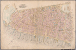


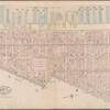
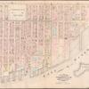
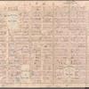
![Plate 10: Bounded by West Street (Hudson River, Piers 39-47), W. 11th Street, 13th Avenue (Hudson River, Piers [52?]-59), W. 14th Street, 7th Avenue, Greenwich Avenue, Perry Street, Waverly Place, Christopher Street, W. 4th Street, 6th Avenue, Bleecker Street, Cottage Place and W. Houston Street](https://images.nypl.org/index.php?id=1512155&t=b)
- The Library Shop
- Privacy Policy
- Rules and Regulations
- Using the Internet
- Website Terms and Conditions
- Gifts of Materials to NYPL
-
© The New York Public Library, 2024
The New York Public Library is a 501(c)(3) | EIN 13-1887440
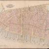
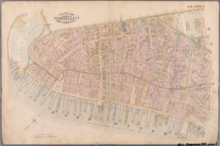
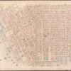
Lionel Pincus and Princess Firyal Map Division, The New York Public Library. "Plate 1: Bounded by Battery Park, Broadway, Chambers Street, New Chambers Street, James Slip, South Street (East River, Piers 1-32), and Battery Park." The New York Public Library Digital Collections. 1885. https://digitalcollections.nypl.org/items/510d47e2-098d-a3d9-e040-e00a18064a99
Lionel Pincus and Princess Firyal Map Division, The New York Public Library. "Plate 1: Bounded by Battery Park, Broadway, Chambers Street, New Chambers Street, James Slip, South Street (East River, Piers 1-32), and Battery Park." New York Public Library Digital Collections. Accessed April 18, 2024. https://digitalcollections.nypl.org/items/510d47e2-098d-a3d9-e040-e00a18064a99
Lionel Pincus and Princess Firyal Map Division, The New York Public Library. (1885). Plate 1: Bounded by Battery Park, Broadway, Chambers Street, New Chambers Street, James Slip, South Street (East River, Piers 1-32), and Battery Park. Retrieved from https://digitalcollections.nypl.org/items/510d47e2-098d-a3d9-e040-e00a18064a99
<ref name=NYPL>{{cite web | url=https://digitalcollections.nypl.org/items/510d47e2-098d-a3d9-e040-e00a18064a99 | title=
(cartographic)
Plate 1: Bounded by Battery Park, Broadway, Chambers Street, New Chambers Street, James Slip, South Street (East River, Piers 1-32), and Battery Park., (1885)
|author=Digital Collections, The New York Public Library |accessdate=April 18, 2024 |publisher=The New York Public Library, Astor, Lenox, and Tilden Foundations}}</ref>