


![Index to Streets and House Numbers. Atlas of the city of Brooklyn. [Aberdeen Street - 59th Street.]](https://images.nypl.org/index.php?id=1512457&t=b)
![Plate 1: [Pier area from the Navy Yard to Clark Street.]](https://images.nypl.org/index.php?id=ps_map_190&t=b)
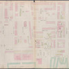
![Plate 2: [Bounded by Clark Street, Fulton Street, Tillary Street, Gold Street, Fulton Street, Bond Street, Atlantic Avenue, Court Street,Amity Street, Columbia Street, Atlantic Avenue and (East River Piers), Furman Street.]](https://images.nypl.org/index.php?id=1512459&t=b)
![Plate 3: [Bounded by Van Brunt Street (East River), Harrison Street, Columbia Street, Amity Street, Court Street, and Hamilton Avenue.]](https://images.nypl.org/index.php?id=1512489&t=b)
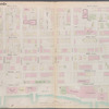
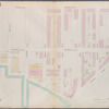
![Plate 4: [Bounded by Atlantic Avenue, Bond Street, Schermerhorn Street, Flatbush Avenue, Fifth Avenue, President Street and Court Street.]](https://images.nypl.org/index.php?id=1512490&t=b)
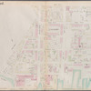
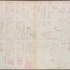
![Plate 5: [Bounded by Clermont Avenue, Greene Avenue, Hanson Place, S. Portland Avenue, Atlantic Avenue, Flatbush Avenue, Schermerhorn Street, Bond Street, Fulton Street, Gold Street, Tillary Street, Navy Street, and Flushing Avenue.]](https://images.nypl.org/index.php?id=1512462&t=b)
![Plate 6: [Bounded by Washington Avenue, Underhill Avenue, Parkway, Ninth Avenue, President Street, Fifth Avenue, Atlantic Avenue, Portland Avenue, Hanson Place, Greene Avenue, Clermont Avenue and Lafayette Avenue.]](https://images.nypl.org/index.php?id=1512464&t=b)
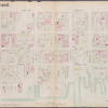
![Plate 7: [Bounded by Lafayette Avenue, Marcy Avenue, Greene Avenue, Tompkins Avenue, Fulton Street, Brooklyn Avenue, Herkimer Street, Bedford Avenue, Atlantic Avenue and Washington Avenue.]](https://images.nypl.org/index.php?id=1512465&t=b)
![Plate 8: [Bounded by Flushing Wallabout Avenue, Nostrand Avenue, Lafayette Avenue and Clermont Avenue.]](https://images.nypl.org/index.php?id=1512467&t=b)
![Plate 9: [Bounded by S. 11th Street, Berry Street, S. 10th Street, Bedford Avenue, S. Ninth Street, Roebling Street, Broadway, Marcy Avenue, S. Fifth Street, Rodney Street, S. Fourth Street, Keap Street, S. Third Street, Hooper Street, S. Second Street, Union Avenue, Broadway, Gwinnett Street, Harrison Street, Flushing AKent Avenue.]](https://images.nypl.org/index.php?id=1512469&t=b)
![Plate 10: [Bounded by N. Second Street, Kent Avenue, N. Third Street, Wythe Avenue, N. Fifth Street, Berry Street, N. Seventh Street, Bedford Avenue, N. Ninth Street, Driggs Street, N. 10th Street, Union Avenue, S. Second Street, Hooper Street, S. Third Street, Keap Street, S. Fourth Street, Rodney Street, S. Fifth Street, Marcy Avenue, Broadway, Roebling Street, S. Ninth Street, Bedford Avenue, S. 10th Street, Berry Street, S. 11th Street, Kent Street and River Street.]](https://images.nypl.org/index.php?id=1512452&t=b)
![Plate 11: [Bounded by Noble Street, Manhattan Avenue, Calyer Street, Diamond Street, Norman Avenue, Newell Street, Van Cott Avenue, Graham Avenue, Bayard Street, N. Eleventh Street,Driggs Street, N. Ninth Street, Bedford Avenue, N. Seventh Street, Berry Street, N. Fifth Street, Wyethe Avenue, N. Third Street, (East River) Kent Avenue, Franklin Street, Quay Street and West Street.]](https://images.nypl.org/index.php?id=1512453&t=b)
![Plate 12: [Bounded by Commercial Street (Newtown Creek), Ash Street, Paidge Avenue, Sutton Street, Calyer Street, Manhattan Avenue, Noble Street, West Street, Dupont Street and Franklin Street.]](https://images.nypl.org/index.php?id=1512455&t=b)
- The Library Shop
- Privacy Policy
- Rules and Regulations
- Using the Internet
- Website Terms and Conditions
- Gifts of Materials to NYPL
-
© The New York Public Library, 2024
The New York Public Library is a 501(c)(3) | EIN 13-1887440
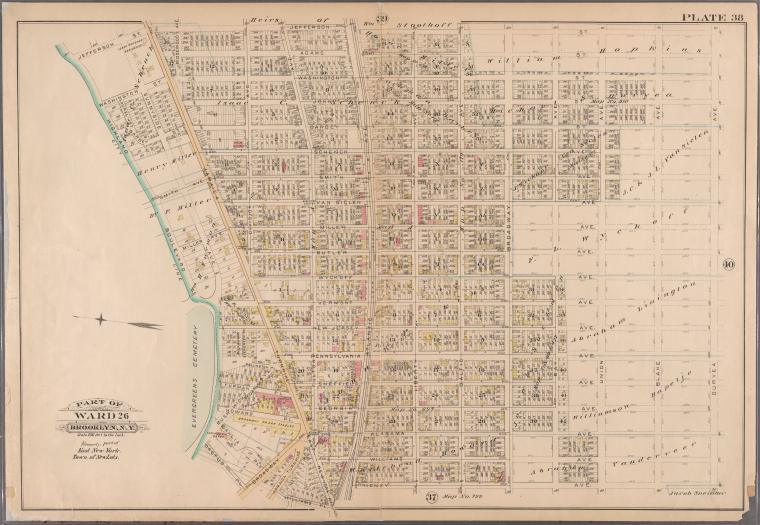
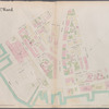
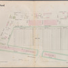
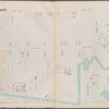
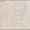
![Plate 38: [Bounded by Jefferson Street, Duryea Avenue, Henry Avenue, Atlantic Avenue, Williams Place, Jamaica Turnpike, Broadway, Cactus Place, and Highland Boulevard.]](https://images.nypl.org/index.php?id=1512488&t=b)
Lionel Pincus and Princess Firyal Map Division, The New York Public Library. "Plate 38: [Bounded by Jefferson Street, Duryea Avenue, Henry Avenue, Atlantic Avenue, Williams Place, Jamaica Turnpike, Broadway, Cactus Place, and Highland Boulevard.]" The New York Public Library Digital Collections. 1886. https://digitalcollections.nypl.org/items/510d47e2-0b90-a3d9-e040-e00a18064a99
Lionel Pincus and Princess Firyal Map Division, The New York Public Library. "Plate 38: [Bounded by Jefferson Street, Duryea Avenue, Henry Avenue, Atlantic Avenue, Williams Place, Jamaica Turnpike, Broadway, Cactus Place, and Highland Boulevard.]" New York Public Library Digital Collections. Accessed April 24, 2024. https://digitalcollections.nypl.org/items/510d47e2-0b90-a3d9-e040-e00a18064a99
Lionel Pincus and Princess Firyal Map Division, The New York Public Library. (1886). Plate 38: [Bounded by Jefferson Street, Duryea Avenue, Henry Avenue, Atlantic Avenue, Williams Place, Jamaica Turnpike, Broadway, Cactus Place, and Highland Boulevard.] Retrieved from https://digitalcollections.nypl.org/items/510d47e2-0b90-a3d9-e040-e00a18064a99
<ref name=NYPL>{{cite web | url=https://digitalcollections.nypl.org/items/510d47e2-0b90-a3d9-e040-e00a18064a99 | title=
(cartographic)
Plate 38: [Bounded by Jefferson Street, Duryea Avenue, Henry Avenue, Atlantic Avenue, Williams Place, Jamaica Turnpike, Broadway, Cactus Place, and Highland Boulevard.], (1886)
|author=Digital Collections, The New York Public Library |accessdate=April 24, 2024 |publisher=The New York Public Library, Astor, Lenox, and Tilden Foundations}}</ref>
![Plate 38: [Bounded by Jefferson Street, Duryea Avenue, Henry Avenue, Atlantic Avenue, Williams Place, Jamaica Turnpike, Broadway, Cactus Place, and Highland Boulevard.]](https://images.nypl.org/index.php?id=1512488&t=t)