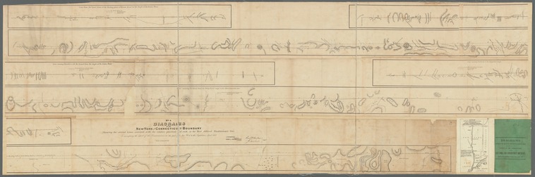
TitleDiagrams of the New-York and Connecticut boundary : showing the several lines surveyed, with the relative position of each to the best definied traditionary line : to accompany the report of the commissioners on the part of New York to the legislature, April 1857
Additional title: No. 4, Diagrams of the New-York and Connecticut boundary showing the several lines surveyed, with the relative position of each to the best definied traditionary line
NamesNew York (State), Commissioners on the New York and Connecticut Boundary (Author)Connecticut. Commission on Boundary between the States of New York and Connecticut (Author)New York (State). Legislature. Senate (Author)Wentz, C. W. (Charles Wesley), 1817-1884 (Engineer)Stephenson, John L., 1821-1862 (Author)
CollectionMaps of New York City and State
Whole
Dates / OriginDate Issued: 1857 (Inferred)Place: Albany, N.Y.?Publisher: The Commissioners
Library locationsLionel Pincus and Princess Firyal Map DivisionShelf locator: Map Div. 15-6027 copy 2 [Filed with N.Y.S. Boundaries]
TopicsBoundariesNew York (State) -- Boundaries -- ConnecticutConnecticut -- Boundaries -- New York (State)New York RegionConnecticutNew York (State)
GenresMaps
NotesVersion identification: Library has a second copy of no. 4 [Map Div. 16-5880] and no. 1 [Map Div. 16-5877] with no. 1, and the cover page of the report entitled: "Diagrams showing the relative position of various lines refered to in the report of the commissioners on the New York and Connecticut boundary, made to the legistlature of New York, April 1857."Funding: Mapping the Nation (NEH grant, 2015-2018)Content: At head of title: No. 4.Content: Scale 1:15,840. "4 in. to a mile" (W 73°59ʹ--W 73°21ʹ/N 42°02ʹ--N 40°59ʹ)Statement of responsibility: C.W Wentz, engineer ; John L. Stephenson, assistant ; Saml. D. Backus [and] J. Tarbell, commrs.Content: Relief shown by hachures.Content: Covers Southeastern portion of New York and parts of Connecticut from the Massachusetts state line to the mouth of the Bryam river. Content: Includes 3 ancillary maps.
Physical DescriptionExtent: 1 sheet 60 x 182,
Type of ResourceCartographic
IdentifiersRLIN/OCLC: 45810119 NYPL catalog ID (B-number): b20645707RLIN/OCLC: 932066140Universal Unique Identifier (UUID): adee4f00-8b0a-0133-c5df-00505686d14e
Rights StatementThe New York Public Library believes that this item is in the public domain under the laws of the United States, but did not make a determination as to its copyright status under the copyright laws of other countries. This item may not be in the public domain under the laws of other countries. Though not required, if you want to credit us as the source, please use the following statement, "From The New York Public Library," and provide a link back to the item on our Digital Collections site. Doing so helps us track how our collection is used and helps justify freely releasing even more content in the future.
Item timeline of events
-
-
-
-