


- The Library Shop
- Privacy Policy
- Rules and Regulations
- Using the Internet
- Website Terms and Conditions
- Gifts of Materials to NYPL
-
© The New York Public Library, 2024
The New York Public Library is a 501(c)(3) | EIN 13-1887440
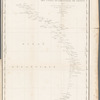
Exposé des travaux relatifs à la reconnaissance hydrographique des côtes, occidentales de France
General Research Division, The New York Public Library. "Carte trigonométrique des côtes occidentales de France" The New York Public Library Digital Collections. 1829. https://digitalcollections.nypl.org/items/5ce9a0b0-1fa2-013a-11f1-0242ac110004
General Research Division, The New York Public Library. "Carte trigonométrique des côtes occidentales de France" New York Public Library Digital Collections. Accessed April 25, 2024. https://digitalcollections.nypl.org/items/5ce9a0b0-1fa2-013a-11f1-0242ac110004
General Research Division, The New York Public Library. (1829). Carte trigonométrique des côtes occidentales de France Retrieved from https://digitalcollections.nypl.org/items/5ce9a0b0-1fa2-013a-11f1-0242ac110004
<ref name=NYPL>{{cite web | url=https://digitalcollections.nypl.org/items/5ce9a0b0-1fa2-013a-11f1-0242ac110004 | title=
(cartographic)
Carte trigonométrique des côtes occidentales de France, (1829)
|author=Digital Collections, The New York Public Library |accessdate=April 25, 2024 |publisher=The New York Public Library, Astor, Lenox, and Tilden Foundations}}</ref>