


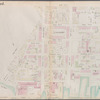
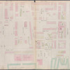
![Brooklyn, Vol. 4, Double Page Plate No. 66; [Map bounded by 3rd St., South 1st St., East River, River St., Kent Ave., Including North 6th St., North 5th St., North 4th St., North 3rd St., North 2nd St., North 1st St., Grand St., Wythe Ave.]](https://images.nypl.org/index.php?id=1695433&t=b)
![Brooklyn, Vol. 4, Double Page Plate No. 67; [Map bounded by Wythe Ave., North 6th St., East River, Kent Ave.; Including North 12th St., North 11th St., North 10th St., North 9th St., North 8th St., North 7th St.]](https://images.nypl.org/index.php?id=1695434&t=b)
![Brooklyn, Vol. 4, Double Page Plate No. 68; [Map bounded by Meserole Ave., Gem St., Franklin St., North 15th St., East River, Kent St., Green Point Ave.; Including Milton St., West St., Noble St., Oak St., Calyer St., Quay St.]](https://images.nypl.org/index.php?id=1695435&t=b)
![Brooklyn, Vol. 4, Double Page Plate No. 69; [Map bounded by Bell St., Pink St., Blue St., Bay St., Maspeth Ave., East Williamsburgh, Newtown Creek, Franklyn St., Kent St.; Including East River Dupont St., Eagle St., Freeman St., West St., Green St., Huron St., India St., Java St.]](https://images.nypl.org/index.php?id=1695436&t=b)
![Brooklyn, Vol. 4, Double Page Plate No. 70; [Map bounded by Vernol Ave., Manhattan Ave. late Union Ave., Commercial St., Box St., Bell St. (Not Opened), Newtown Creek, River St.; Including Pier St., Dock St., South St., Flushing St., Front St., Borond St., West 3rd St., West 4th St.]](https://images.nypl.org/index.php?id=1695437&t=b)
![Brooklyn, Vol. 4, Double Page Plate No. 71; [Map bounded by Vernon Ave., West 4th St., West 5th St., West 6th St., West 7th St., West 8th St.; Including West Ave.]](https://images.nypl.org/index.php?id=1695438&t=b)
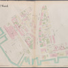
![Brooklyn, Vol. 4, Double Page Plate No. 72; [Map bounded by Jacks Creek, East 3rd St., Vernon Ave., East 11th St., East 10th St., East 9th St., East 8th St., East 7th St., East 6th St., East 5th St., East 4th St.; Including East Ave., Van Alst Ave., Jackson Ave.]](https://images.nypl.org/index.php?id=1695439&t=b)
![Brooklyn, Vol. 4, Double Page Plate No. 73; [Map bounded by Jacks Creek, Ranton St., Pequod St., Shawnet St., Paidge Ave., Prorost St., Eagle St., Du Pont St., Clay St., Box St.; Including Manhattan Ave. Late Union Place, Ash St., Oakland St., Newtown Creek, Ventron Ave., Jackson Ave., East 3rd St., East Ave., East 2nd St., Borden Ave., 1st St.]](https://images.nypl.org/index.php?id=1695440&t=b)
![Brooklyn, Vol. 4, Double Page Plate No. 74; [Map bounded by Manhattan Ave. Late Union Place, Commercial St., Oakland St., Greenpoint St., Franklin St., Clay St., Dupoint St.; Including Eagle St., Freeman St., Green St., Huron St., India St., Java St., Kent St.]](https://images.nypl.org/index.php?id=1695441&t=b)
![Brooklyn, Vol. 4, Double Page Plate No. 75; [Map bounded by Meeker Ave., Scott Ave., Newtown Creek, Newel St., Meserole Ave., Franklin St., Greenpoint Ave., Milton St., Noble St; Including Oak St., Calyer St., Dobbin St., Guernsey St., Lorimer St., Orchard St., Leonard St., Eckford St., Oakland St.]](https://images.nypl.org/index.php?id=1695442&t=b)
![Brooklyn, Vol. 4, Double Page Plate No. 76; [Map bounded by North 14th St., North 15th St., 5th St., Guernsey St., Lorimer St., Van Cott Ave., Oakland St., Newel St., Bancker St., Meserole Ave.; Including Banker St., 2nd St., Norman Ave., 3rd St., Dobbin St., Nassau Ave., Guernsey St., Lorimer St., Manhattan Ave. Late Union Place, Leonard St., Eckford St.]](https://images.nypl.org/index.php?id=1695443&t=b)
![Brooklyn, Vol. 4, Double Page Plate No. 77; [Map bounded by Driggs St. late 5th St., North 6th St., 7th St., 8th St., 9th St., 10th St., 11th St., 12th St., 13th St., 14th St., 15th St., Wythe Ave. late 2nd St.; Including Eckford St., Van Cott Ave., Van Pelt St., Graham Ave., Newton St., Ewen St., Bayard St., Leonard St., Meeker Ave., Richardson St., Ewen St.]](https://images.nypl.org/index.php?id=1695444&t=b)
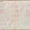
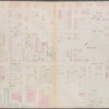
![Brooklyn, Vol. 4, Double Page Plate No. 78; [Map bounded by Roebling St. late South St., South 3rd St., South 2nd St., South 1st St., Grand St., North 1st St.; Including North 2nd St., North 3rd St., North 4th St., North 5th St., North 6th St., Bedford Ave. late 4th St.]](https://images.nypl.org/index.php?id=1695445&t=b)
- The Library Shop
- Privacy Policy
- Rules and Regulations
- Using the Internet
- Website Terms and Conditions
- Gifts of Materials to NYPL
-
© The New York Public Library, 2024
The New York Public Library is a 501(c)(3) | EIN 13-1887440
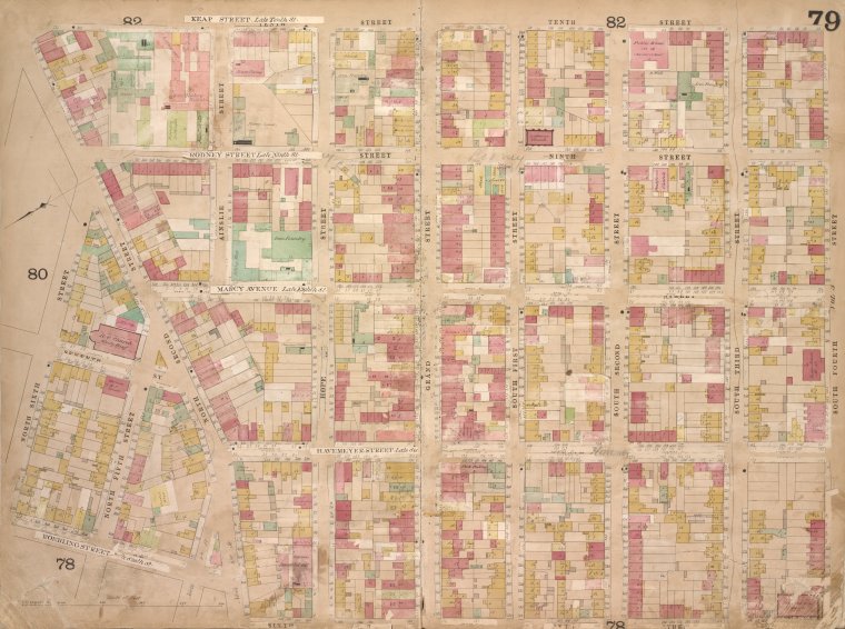
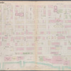
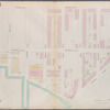
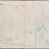
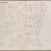
![Brooklyn, Vol. 4, Double Page Plate No. 79; [Map bounded by Keap St. late 10th St., South 4th St., South 3rd St., South 2nd St., South 1st St., Grand St., Hope St.; Including North 2nd St., North 6th St., North 5th St., 7th St., Roebling St. late 6th St., Havemeyer St. late 7th St., Marcy Ave. late 8th St., Rodney St. late 9th St.]](https://images.nypl.org/index.php?id=1695446&t=b)
Higginson's insurance maps of the city of Brooklyn L. I. : surveyed, drawn & published [1868]
Lionel Pincus and Princess Firyal Map Division, The New York Public Library. "Brooklyn, Vol. 4, Double Page Plate No. 79; [Map bounded by Keap St. late 10th St., South 4th St., South 3rd St., South 2nd St., South 1st St., Grand St., Hope St.; Including North 2nd St., North 6th St., North 5th St., 7th St., Roebling St. late 6th St., Havemeyer St. late 7th St., Marcy Ave. late 8th St., Rodney St. late 9th St.]" The New York Public Library Digital Collections. 1868. https://digitalcollections.nypl.org/items/64b498f8-4a83-c936-e040-e00a1806393b
Lionel Pincus and Princess Firyal Map Division, The New York Public Library. "Brooklyn, Vol. 4, Double Page Plate No. 79; [Map bounded by Keap St. late 10th St., South 4th St., South 3rd St., South 2nd St., South 1st St., Grand St., Hope St.; Including North 2nd St., North 6th St., North 5th St., 7th St., Roebling St. late 6th St., Havemeyer St. late 7th St., Marcy Ave. late 8th St., Rodney St. late 9th St.]" New York Public Library Digital Collections. Accessed April 19, 2024. https://digitalcollections.nypl.org/items/64b498f8-4a83-c936-e040-e00a1806393b
Lionel Pincus and Princess Firyal Map Division, The New York Public Library. (1868). Brooklyn, Vol. 4, Double Page Plate No. 79; [Map bounded by Keap St. late 10th St., South 4th St., South 3rd St., South 2nd St., South 1st St., Grand St., Hope St.; Including North 2nd St., North 6th St., North 5th St., 7th St., Roebling St. late 6th St., Havemeyer St. late 7th St., Marcy Ave. late 8th St., Rodney St. late 9th St.] Retrieved from https://digitalcollections.nypl.org/items/64b498f8-4a83-c936-e040-e00a1806393b
<ref name=NYPL>{{cite web | url=https://digitalcollections.nypl.org/items/64b498f8-4a83-c936-e040-e00a1806393b | title=
(cartographic)
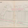
Brooklyn, Vol. 4, Double Page Plate No. 79; [Map bounded by Keap St. late 10th St., South 4th St., South 3rd St., South 2nd St., South 1st St., Grand St., Hope St.; Including North 2nd St., North 6th St., North 5th St., 7th St., Roebling St. late 6th St., Havemeyer St. late 7th St., Marcy Ave. late 8th St., Rodney St. late 9th St.], (1868)
|author=Digital Collections, The New York Public Library |accessdate=April 19, 2024 |publisher=The New York Public Library, Astor, Lenox, and Tilden Foundations}}</ref>
![Brooklyn, Vol. 4, Double Page Plate No. 79; [Map bounded by Keap St. late 10th St., South 4th St., South 3rd St., South 2nd St., South 1st St., Grand St., Hope St.; Including North 2nd St., North 6th St., North 5th St., 7th St., Roebling St. late 6th St., Havemeyer St. late 7th St., Marcy Ave. late 8th St., Rodney St. late 9th St.]](https://images.nypl.org/index.php?id=1695446&t=t)