


![Central Park : memorial of the Common Council of the City of New York to the Legislature, approved June 11th, 1853...[title page]](https://images.nypl.org/index.php?id=5190254&t=b)


- The Library Shop
- Privacy Policy
- Rules and Regulations
- Using the Internet
- Website Terms and Conditions
- Gifts of Materials to NYPL
-
© The New York Public Library, 2024
The New York Public Library is a 501(c)(3) | EIN 13-1887440
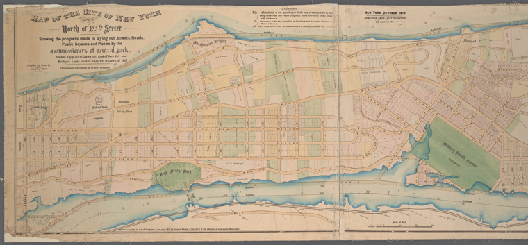
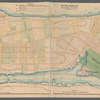
Lionel Pincus and Princess Firyal Map Division, The New York Public Library. "Map of the City of New York north of 155th Street : showing the progress made in laying out streets, roads, public squares and places by the Commissioners of Central Park under chap. 565 of laws 1865 and of New Pier and Bulkhead Lines under chap. 695 of laws of 1867 / compiled and drawn by Edward S. Ewen" The New York Public Library Digital Collections. 1873. https://digitalcollections.nypl.org/items/6ba73470-f3a2-0130-9d9e-58d385a7b928
Lionel Pincus and Princess Firyal Map Division, The New York Public Library. "Map of the City of New York north of 155th Street : showing the progress made in laying out streets, roads, public squares and places by the Commissioners of Central Park under chap. 565 of laws 1865 and of New Pier and Bulkhead Lines under chap. 695 of laws of 1867 / compiled and drawn by Edward S. Ewen" New York Public Library Digital Collections. Accessed April 19, 2024. https://digitalcollections.nypl.org/items/6ba73470-f3a2-0130-9d9e-58d385a7b928
Lionel Pincus and Princess Firyal Map Division, The New York Public Library. (1873). Map of the City of New York north of 155th Street : showing the progress made in laying out streets, roads, public squares and places by the Commissioners of Central Park under chap. 565 of laws 1865 and of New Pier and Bulkhead Lines under chap. 695 of laws of 1867 / compiled and drawn by Edward S. Ewen Retrieved from https://digitalcollections.nypl.org/items/6ba73470-f3a2-0130-9d9e-58d385a7b928
<ref name=NYPL>{{cite web | url=https://digitalcollections.nypl.org/items/6ba73470-f3a2-0130-9d9e-58d385a7b928 | title=
(cartographic)
Map of the City of New York north of 155th Street : showing the progress made in laying out streets, roads, public squares and places by the Commissioners of Central Park under chap. 565 of laws 1865 and of New Pier and Bulkhead Lines under chap. 695 of laws of 1867 / compiled and drawn by Edward S. Ewen, (1873)|author=Digital Collections, The New York Public Library |accessdate=April 19, 2024 |publisher=The New York Public Library, Astor, Lenox, and Tilden Foundations}}</ref>