


![Bronx, V. A, Plate No. 1 [Map bounded by Fordham Ave., Bear Swamp Rd., Bronx River]](https://images.nypl.org/index.php?id=2003516&t=b)
![Bronx, V. A, Plate No. 2 [Map bounded by Bear Swamp Rd., Fordham Ave.]](https://images.nypl.org/index.php?id=2003517&t=b)
![Bronx, V. A, Plate No. 3 [Map bounded by Bear Swamp Rd., Bronx Park]](https://images.nypl.org/index.php?id=2003518&t=b)
![Bronx, V. A, Plate No. 4 [Map bounded by Morris Park Ave., Bronxdale & Unionport Rd.]](https://images.nypl.org/index.php?id=2003519&t=b)
![Bronx, V. A, Plate No. 5 [Map bounded by Fordham Ave., Williamsbridge Rd., Bear Swamp Rd.]](https://images.nypl.org/index.php?id=2003520&t=b)
![Bronx, V. A, Plate No. 6 [Map bounded by Williamsbridge Rd., Bear Swamp Rd.]](https://images.nypl.org/index.php?id=2003521&t=b)
![Bronx, V. A, Plate No. 7 [Map bounded by Morris Park Ave., West Farms Rd., Unionport Rd.]](https://images.nypl.org/index.php?id=2003522&t=b)
![Bronx, V. A, Plate No. 8 [Map bounded by Morris Park Ave., Bear Swamp Rd., W. Farms Rd., Madison St.]](https://images.nypl.org/index.php?id=2003523&t=b)
![Bronx, V. A, Plate No. 9 [Map bounded by Morris Park Ave., W. Farms Rd.]](https://images.nypl.org/index.php?id=2003524&t=b)
![Bronx, V. A, Plate No. 10 [Map bounded by Morris Park Ave., Unionport Rd., W. Farms Rd., Hancock St.]](https://images.nypl.org/index.php?id=2003525&t=b)
![Bronx, V. A, Plate No. 11 [Map bounded by Morris Park Ave., Bronx Park]](https://images.nypl.org/index.php?id=2003526&t=b)
![Bronx, V. A, Plate No. 12 [Map bounded by Watson's Lane, Bronx River, W. Farms Rd.]](https://images.nypl.org/index.php?id=2003527&t=b)
![Brooklyn Vol. A Plate No. 1 [Map bounded by 59th St, 60th St., 61st St., 62nd St., 63rd St.; Including 2nd Ave., 3rd Ave., 4th Ave.]](https://images.nypl.org/index.php?id=1808769&t=b)
![Brooklyn Vol. A Plate No. 2 [Map bounded by 63rd St., 64th St., 65th St., 67th St., Wakeman Place; Including 2nd Ave., 3rd Ave., 4th Ave.]](https://images.nypl.org/index.php?id=1808770&t=b)
![Brooklyn Vol. A Plate No. 3 [Map bounded by Wakeman St., 66th St., 67th St., Senator St., 68th St.; Including 2nd Ave., 3rd Ave., 4th Ave.]](https://images.nypl.org/index.php?id=1808771&t=b)
![Brooklyn Vol. A Plate No. 4 [Map bounded by 68th St., Bay Ridge Ave., Ovington Ave.; Including 2nd Ave., 3rd Ave., 4th Ave.]](https://images.nypl.org/index.php?id=1808772&t=b)
![Brooklyn Vol. A Plate No. 5 [Map bounded by Ovington Ave., 71st St., 72nd St., 73rd St., 74th St.; Including 2nd Ave., 3rd Ave., 4th Ave.]](https://images.nypl.org/index.php?id=1808773&t=b)
![Brooklyn Vol. A Plate No. 6 [Map bounded by 74th St., 75th St., 76th St., 77th St.; Including 2nd Ave., 3rd Ave., 4th Ave.]](https://images.nypl.org/index.php?id=1808774&t=b)
![Brooklyn Vol. A Plate No. 7 [Map bounded by 77th St., 78th St., 79th St., 80th St.; Including 2nd Ave., 3rd Ave., 4th Ave.]](https://images.nypl.org/index.php?id=1808775&t=b)
![Brooklyn Vol. A Plate No. 8 [Map bounded by 80th St., 81st St., 82nd St., 83rd St.; Including 2nd Ave., 3rd Ave., 4th Ave.]](https://images.nypl.org/index.php?id=1808776&t=b)
![Brooklyn Vol. A Plate No. 9 [Map bounded by 83rd St., 84th St., 85th St., 86th St.; Including 2nd Ave., 3rd Ave., 4th Ave.]](https://images.nypl.org/index.php?id=1808777&t=b)
![Brooklyn Vol. A Plate No. 10 [Map bounded by 86th St., 87th St., 88th St., 89thSt.; Including 2nd Ave., 3rd Ave., 4th Ave.]](https://images.nypl.org/index.php?id=1808778&t=b)
![Brooklyn Vol. A Plate No. 11 [Map bounded by89th St., 90th St., 91st St., 92nd St.; Including 2nd Ave., 3rd Ave., 4th Ave.]](https://images.nypl.org/index.php?id=1808779&t=b)
![Brooklyn Vol. A Plate No. 12 [Map bounded by 92nd St., 93rd St., 94th St., 95th St.; Including 2nd Ave., 3rd Ave., 4th Ave.]](https://images.nypl.org/index.php?id=1808780&t=b)
![Brooklyn Vol. A Plate No. 13 [Map bounded by 95th St., 96th St., 97th St.; Including Marine Ave., 3rd Ave., 4thAve.]](https://images.nypl.org/index.php?id=1808781&t=b)
![Brooklyn Vol. B Plate No. 131 [Map bounded by Bay 7th St., Benson Ave., Bay 11th St., Cropsey Ave.]](https://images.nypl.org/index.php?id=1808872&t=b)
![Brooklyn Vol. B Plate No. 132 [Map bounded by Bay 11th St., Bath Ave., Bay 14th St., New York Bay]](https://images.nypl.org/index.php?id=1808873&t=b)
![Brooklyn Vol. B Plate No. 133 [Map bounded by Bay 14th St., Bath Ave., New York Bay]](https://images.nypl.org/index.php?id=1808874&t=b)
![Brooklyn Vol. B Plate No. 134 [Map bounded by Bath Ave., Bay 22nd St., New York Bay]](https://images.nypl.org/index.php?id=1808875&t=b)
![Brooklyn Vol. B Plate No. 135 [Map bounded by Bay 22nd St., Bath Ave., Bay 26th St., Warehouse Ave.]](https://images.nypl.org/index.php?id=1808876&t=b)
![Brooklyn Vol. B Plate No. 136 [Map bounded by Bath Ave., 22nd Ave., Warehouse Ave.]](https://images.nypl.org/index.php?id=1808877&t=b)
![Brooklyn Vol. B Plate No. 137 [Map bounded by 22nd Ave., Benson Ave., Bay 34th St., Cropsey Ave.]](https://images.nypl.org/index.php?id=1808878&t=b)
![Brooklyn Vol. B Plate No. 138 [Map bounded by 22nd Ave., Cropsey Ave., Warehouse Ave.]](https://images.nypl.org/index.php?id=1808879&t=b)
![Brooklyn Vol. B Plate No. 139 [Map bounded by Gravesend Bay, Cropsey Ave., Harway Ave., Bay 41st St.]](https://images.nypl.org/index.php?id=1808880&t=b)
![Brooklyn Vol. B Plate No. 140 [Map bounded by Warehouse Ave., Bay 41st St., Harway Ave., Bay 46th St.]](https://images.nypl.org/index.php?id=1808881&t=b)
![Brooklyn Vol. B Plate No. 141 [Map bounded by Bay 34th St., Benson Ave., Bay 38th St., Cropsey Ave.]](https://images.nypl.org/index.php?id=1808882&t=b)
![Brooklyn Vol. B Plate No. 142 [Map bounded by Bath Ave., Bay 38th St., Benson Ave., Bay 43rd St.]](https://images.nypl.org/index.php?id=1808883&t=b)
![Brooklyn Vol. B Plate No. 143 [Map bounded by Bay 38th St., Bath Ave., 26th Ave., Harway Ave.]](https://images.nypl.org/index.php?id=1808884&t=b)
![Brooklyn Vol. B Plate No. 144 [Map bounded by 26th Ave., Bath Ave., Bay 46th St., Harway Ave.]](https://images.nypl.org/index.php?id=1808885&t=b)
- The Library Shop
- Privacy Policy
- Rules and Regulations
- Using the Internet
- Website Terms and Conditions
- Gifts of Materials to NYPL
-
© The New York Public Library, 2024
The New York Public Library is a 501(c)(3) | EIN 13-1887440
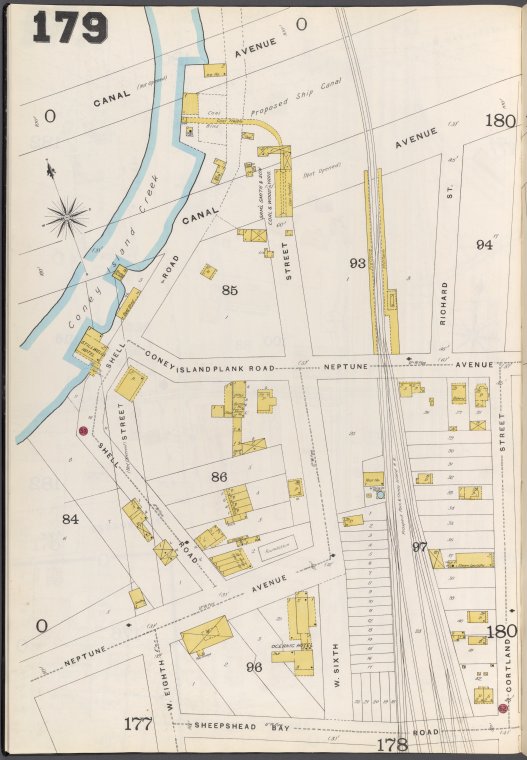
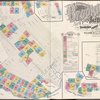
![Brooklyn Vol. B Plate No. 179 [Map bounded by Canal Ave., Coney Island Creek, Cortland St., Sheepshead Bay Road]](https://images.nypl.org/index.php?id=1808920&t=b)
Lionel Pincus and Princess Firyal Map Division, The New York Public Library. "Brooklyn Vol. B Plate No. 179 [Map bounded by Canal Ave., Coney Island Creek, Cortland St., Sheepshead Bay Road]" The New York Public Library Digital Collections. 1884 - 1936. https://digitalcollections.nypl.org/items/7aca66be-5c78-342f-e040-e00a180628de
Lionel Pincus and Princess Firyal Map Division, The New York Public Library. "Brooklyn Vol. B Plate No. 179 [Map bounded by Canal Ave., Coney Island Creek, Cortland St., Sheepshead Bay Road]" New York Public Library Digital Collections. Accessed April 20, 2024. https://digitalcollections.nypl.org/items/7aca66be-5c78-342f-e040-e00a180628de
Lionel Pincus and Princess Firyal Map Division, The New York Public Library. (1884 - 1936). Brooklyn Vol. B Plate No. 179 [Map bounded by Canal Ave., Coney Island Creek, Cortland St., Sheepshead Bay Road] Retrieved from https://digitalcollections.nypl.org/items/7aca66be-5c78-342f-e040-e00a180628de
<ref name=NYPL>{{cite web | url=https://digitalcollections.nypl.org/items/7aca66be-5c78-342f-e040-e00a180628de | title=
(cartographic)
Brooklyn Vol. B Plate No. 179 [Map bounded by Canal Ave., Coney Island Creek, Cortland St., Sheepshead Bay Road], (1884 - 1936)
|author=Digital Collections, The New York Public Library |accessdate=April 20, 2024 |publisher=The New York Public Library, Astor, Lenox, and Tilden Foundations}}</ref>
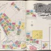
![Brooklyn Vol. B Plate No. 179 [Map bounded by Canal Ave., Coney Island Creek, Cortland St., Sheepshead Bay Road]](https://images.nypl.org/index.php?id=1808920&t=t)