


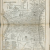
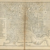
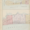
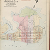
![Atlantic City, Double Page Plate No. 1 [Map bounded by Pacific Ave., Atlantic Ocean, Maryland Ave.]](https://images.nypl.org/index.php?id=3905954&t=b)
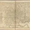
![Atlantic City, Double Page Plate No. 2 [Map bounded by Pacific Ave., Maryland Ave., Atlantic Ocean, Kentucky Ave.]](https://images.nypl.org/index.php?id=3905955&t=b)
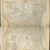
![Atlantic City, Double Page Plate No. 3 [Map bounded by Pacific Ave., Kentucky Ave., Atlantic Ocean, Mississippi Ave.]](https://images.nypl.org/index.php?id=3905956&t=b)
![Atlantic City, Double Page Plate No. 4 [Map bounded by Atlantic Ave., Mississippi Ave., Atlantic Ocean, Stenton Pl.]](https://images.nypl.org/index.php?id=3905957&t=b)
![Atlantic City, Double Page Plate No. 5 [Map bounded by Vermont Ave., Mediterranean Ave., Atlantic Ocean, Pacific Ave.]](https://images.nypl.org/index.php?id=3905958&t=b)
![Atlantic City, Double Page Plate No. 6 [Map bounded by Vermont Ave., Pacific Ave., New Jersey Ave., Mediterranean Ave.]](https://images.nypl.org/index.php?id=3905959&t=b)
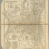
![Atlantic City, Double Page Plate No. 7 [Map bounded by New Jersey Ave., Pacific Ave., Pennsylvania Ave., Mediterranean Ave.]](https://images.nypl.org/index.php?id=3905960&t=b)
![Atlantic City, Double Page Plate No. 8 [Map bounded by Pennsylvania Ave., Pacific Ave., New York Ave., Mediterranean Ave.]](https://images.nypl.org/index.php?id=3905961&t=b)
![Atlantic City, Double Page Plate No. 9 [Map bounded by New York Ave., Pacific Ave., Ohio Ave., Mediterranean Ave.]](https://images.nypl.org/index.php?id=3905962&t=b)
![Atlantic City, Double Page Plate No. 10 [Map bounded by Ohio Ave., Pacific Ave., Mississippi Ave., Mediterranean Ave.]](https://images.nypl.org/index.php?id=3905963&t=b)
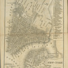
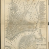
![Atlantic City, Double Page Plate No. 11 [Map bounded by Mississippi Ave., Atlantic Ave., California Ave., Beach Thoroughfare]](https://images.nypl.org/index.php?id=3905964&t=b)
![Atlantic City, Double Page Plate No. 12 [Map bounded by California Ave., Atlantic Ocean, Boston Ave., Beach Thoroughfare]](https://images.nypl.org/index.php?id=3905965&t=b)
- The Library Shop
- Privacy Policy
- Rules and Regulations
- Using the Internet
- Website Terms and Conditions
- Gifts of Materials to NYPL
-
© The New York Public Library, 2024
The New York Public Library is a 501(c)(3) | EIN 13-1887440
Lionel Pincus and Princess Firyal Map Division, The New York Public Library. "Topographical maps of New Jersey" The New York Public Library Digital Collections. 1899 - 1926. https://digitalcollections.nypl.org/items/826474f0-c5ed-012f-2e13-58d385a7bc34
Lionel Pincus and Princess Firyal Map Division, The New York Public Library. "Topographical maps of New Jersey" New York Public Library Digital Collections. Accessed April 24, 2024. https://digitalcollections.nypl.org/items/826474f0-c5ed-012f-2e13-58d385a7bc34
Lionel Pincus and Princess Firyal Map Division, The New York Public Library. (1899 - 1926). Topographical maps of New Jersey Retrieved from https://digitalcollections.nypl.org/items/826474f0-c5ed-012f-2e13-58d385a7bc34
<ref name=NYPL>{{cite web | url=https://digitalcollections.nypl.org/items/826474f0-c5ed-012f-2e13-58d385a7bc34 | title=
(cartographic)
Topographical maps of New Jersey, (1899 - 1926)|author=Digital Collections, The New York Public Library |accessdate=April 24, 2024 |publisher=The New York Public Library, Astor, Lenox, and Tilden Foundations}}</ref>
