


- The Library Shop
- Privacy Policy
- Rules and Regulations
- Using the Internet
- Website Terms and Conditions
- Gifts of Materials to NYPL
-
© The New York Public Library, 2024
The New York Public Library is a 501(c)(3) | EIN 13-1887440
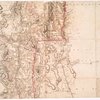
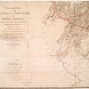
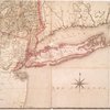
Lionel Pincus and Princess Firyal Map Division, The New York Public Library. "A chorographical map of the province of New-York in North America, divided into counties, manors, patents and townships : exhibiting likewise all the private grants of land made and located in that Province" The New York Public Library Digital Collections. 1779. https://digitalcollections.nypl.org/items/8b829b44-1cce-6876-e040-e00a1806523f
Lionel Pincus and Princess Firyal Map Division, The New York Public Library. "A chorographical map of the province of New-York in North America, divided into counties, manors, patents and townships : exhibiting likewise all the private grants of land made and located in that Province" New York Public Library Digital Collections. Accessed April 19, 2024. https://digitalcollections.nypl.org/items/8b829b44-1cce-6876-e040-e00a1806523f
Lionel Pincus and Princess Firyal Map Division, The New York Public Library. (1779). A chorographical map of the province of New-York in North America, divided into counties, manors, patents and townships : exhibiting likewise all the private grants of land made and located in that Province Retrieved from https://digitalcollections.nypl.org/items/8b829b44-1cce-6876-e040-e00a1806523f
<ref name=NYPL>{{cite web | url=https://digitalcollections.nypl.org/items/8b829b44-1cce-6876-e040-e00a1806523f | title=
(cartographic)
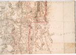
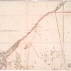
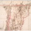
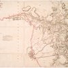
A chorographical map of the province of New-York in North America, divided into counties, manors, patents and townships : exhibiting likewise all the private grants of land made and located in that Province, (1779)
|author=Digital Collections, The New York Public Library |accessdate=April 19, 2024 |publisher=The New York Public Library, Astor, Lenox, and Tilden Foundations}}</ref>