![Mirʺ sʺ B[o]gomʺ ch[e]lovĕkū](https://images.nypl.org/index.php?id=58509201&t=b)


- The Library Shop
- Privacy Policy
- Rules and Regulations
- Using the Internet
- Website Terms and Conditions
- Gifts of Materials to NYPL
-
© The New York Public Library, 2024
The New York Public Library is a 501(c)(3) | EIN 13-1887440
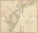
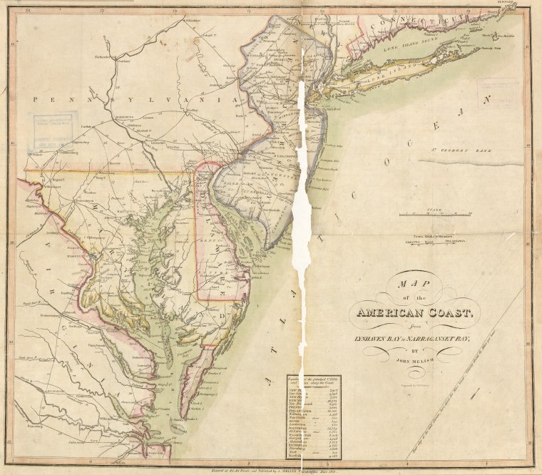
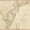
Rare Book Division, The New York Public Library. "Map of the American Coast, from Lynhaven Bay to Narraganset Bay" The New York Public Library Digital Collections. 1813. https://digitalcollections.nypl.org/items/8fc5e848-61ad-c79e-e040-e00a1806094e
Rare Book Division, The New York Public Library. "Map of the American Coast, from Lynhaven Bay to Narraganset Bay" New York Public Library Digital Collections. Accessed April 19, 2024. https://digitalcollections.nypl.org/items/8fc5e848-61ad-c79e-e040-e00a1806094e
Rare Book Division, The New York Public Library. (1813). Map of the American Coast, from Lynhaven Bay to Narraganset Bay Retrieved from https://digitalcollections.nypl.org/items/8fc5e848-61ad-c79e-e040-e00a1806094e
<ref name=NYPL>{{cite web | url=https://digitalcollections.nypl.org/items/8fc5e848-61ad-c79e-e040-e00a1806094e | title=
(cartographic)
Map of the American Coast, from Lynhaven Bay to Narraganset Bay, (1813)
|author=Digital Collections, The New York Public Library |accessdate=April 19, 2024 |publisher=The New York Public Library, Astor, Lenox, and Tilden Foundations}}</ref>