


![Bronx, V. A, Plate No. 1 [Map bounded by Fordham Ave., Bear Swamp Rd., Bronx River]](https://images.nypl.org/index.php?id=2003516&t=b)
![Bronx, V. A, Plate No. 2 [Map bounded by Bear Swamp Rd., Fordham Ave.]](https://images.nypl.org/index.php?id=2003517&t=b)
![Bronx, V. A, Plate No. 3 [Map bounded by Bear Swamp Rd., Bronx Park]](https://images.nypl.org/index.php?id=2003518&t=b)
![Bronx, V. A, Plate No. 4 [Map bounded by Morris Park Ave., Bronxdale & Unionport Rd.]](https://images.nypl.org/index.php?id=2003519&t=b)
![Bronx, V. A, Plate No. 5 [Map bounded by Fordham Ave., Williamsbridge Rd., Bear Swamp Rd.]](https://images.nypl.org/index.php?id=2003520&t=b)
![Bronx, V. A, Plate No. 6 [Map bounded by Williamsbridge Rd., Bear Swamp Rd.]](https://images.nypl.org/index.php?id=2003521&t=b)
![Bronx, V. A, Plate No. 7 [Map bounded by Morris Park Ave., West Farms Rd., Unionport Rd.]](https://images.nypl.org/index.php?id=2003522&t=b)
![Bronx, V. A, Plate No. 8 [Map bounded by Morris Park Ave., Bear Swamp Rd., W. Farms Rd., Madison St.]](https://images.nypl.org/index.php?id=2003523&t=b)
![Bronx, V. A, Plate No. 9 [Map bounded by Morris Park Ave., W. Farms Rd.]](https://images.nypl.org/index.php?id=2003524&t=b)
![Bronx, V. A, Plate No. 10 [Map bounded by Morris Park Ave., Unionport Rd., W. Farms Rd., Hancock St.]](https://images.nypl.org/index.php?id=2003525&t=b)
![Bronx, V. A, Plate No. 11 [Map bounded by Morris Park Ave., Bronx Park]](https://images.nypl.org/index.php?id=2003526&t=b)
![Bronx, V. A, Plate No. 12 [Map bounded by Watson's Lane, Bronx River, W. Farms Rd.]](https://images.nypl.org/index.php?id=2003527&t=b)
![Manhattan, V. 1, Plate No. 1 west half [Map bounded by Beaver St., Broad St., South St., State St.]](https://images.nypl.org/index.php?id=1992434&t=b)
![Manhattan, V. 1, Plate No. 1 [Map bounded by Beaver St., Willim St., East River, Broad St.]](https://images.nypl.org/index.php?id=1992435&t=b)
![Manhattan, V. 1, Double Page Plate No. 2 [Map bounded by Wall St., William St., Beaver St., Battery Pl., West St., Rector St.]](https://images.nypl.org/index.php?id=1992436&t=b)
![Manhattan, V. 1, Plate No. 3 west half [Map bounded by Dey St., Trinity Pl., Church St., Rector St., West St.]](https://images.nypl.org/index.php?id=1992437&t=b)
![Manhattan, V. 1, Plate No. 3 [Map bounded by Dey St., Nassau St., Rector St., Trinity Pl., Church St.]](https://images.nypl.org/index.php?id=1992438&t=b)
![Manhattan, V. 1, Plate No. 4 west half [Map bounded by Maidey Lane, Pearl St., Exchange Pl., Broad St.]](https://images.nypl.org/index.php?id=1992439&t=b)
![Manhattan, V. 1, Plate No. 4 [Map bounded by Maiden Lane, East River, Old Slip, Pearl St.]](https://images.nypl.org/index.php?id=1992440&t=b)
![Manhattan, V. 1, Plate No. 5 south half [Map bounded by Gold St., Beekman St., South St., Maiden Lane]](https://images.nypl.org/index.php?id=1992441&t=b)
![Manhattan, V. 1, Plate No. 5 [Map bounded by Gold St., Dover St., Frankfort St., South St., Fulton St.]](https://images.nypl.org/index.php?id=1992442&t=b)
![Manhattan, V. 1, Plate No. 6 south half [Map bounded by Broadway, Fulton St., Gold St., Liberty St.]](https://images.nypl.org/index.php?id=1992443&t=b)
![Manhattan, V. 1, Plate No. 6 [Map bounded by Broadway, Frankfort St., Gold St., Fulton St.]](https://images.nypl.org/index.php?id=1992444&t=b)
![Manhattan, V. 1, Plate No. 7 west half [Map bounded by Murray St., College Pl., Dey St., West St.]](https://images.nypl.org/index.php?id=1992445&t=b)
![Manhattan, V. 4, Plate No. 1 [Map bounded by 6th Ave., W. 25th St., 5th Ave., W. 22nd St.]](https://images.nypl.org/index.php?id=1993021&t=b)
![Manhattan, V. 4, Plate No. 2 [Map bounded by 6th Ave., W. 28th St., 5th Ave., W. 25th St.]](https://images.nypl.org/index.php?id=1993022&t=b)
![Manhattan, V. 4, Plate No. 3 [Map bounded by 5th Ave., E. 25th St., 4th Ave., E. 22nd St.]](https://images.nypl.org/index.php?id=1993023&t=b)
![Manhattan, V. 4, Plate No. 4 [Map bounded by 5th Ave., E. 28th St., 4th Ave., E. 25th St.]](https://images.nypl.org/index.php?id=1993024&t=b)
![Manhattan, V. 4, Plate No. 6 [Map bounded by 4th Ave., E. 28th St., 3rd Ave., E. 25th St.]](https://images.nypl.org/index.php?id=1993026&t=b)
![Manhattan, V. 4, Plate No. 7 [Map bounded by E. 26th St., 2nd Ave., E. 22nd St., 3rd Ave.]](https://images.nypl.org/index.php?id=1993027&t=b)
![Manhattan, V. 4, Plate No. 8 [Map bounded by E. 30th St., 2nd Ave., E. 26th St., 3rd Ave.]](https://images.nypl.org/index.php?id=1993028&t=b)
![Manhattan, V. 4, Plate No. 9 [Map bounded by E. 26th St., 1st Ave., E. 22nd St., 2nd Ave.]](https://images.nypl.org/index.php?id=1993029&t=b)
![Manhattan, V. 4, Plate No. 10 [Map bounded by E. 30th St., 1st Ave., E. 26th St., 2nd Ave.]](https://images.nypl.org/index.php?id=1993030&t=b)
![Manhattan, V. 4, Plate No. 11 [Map bounded by E. 26th St., Avenue A, E. 22nd St., 1st Ave.]](https://images.nypl.org/index.php?id=1993031&t=b)
![Manhattan, V. 4, Plate No. 12 [Map bounded by Avenue A, E. 25th St., East River, E. 22nd St.]](https://images.nypl.org/index.php?id=1993032&t=b)
- The Library Shop
- Privacy Policy
- Rules and Regulations
- Using the Internet
- Website Terms and Conditions
- Gifts of Materials to NYPL
-
© The New York Public Library, 2024
The New York Public Library is a 501(c)(3) | EIN 13-1887440
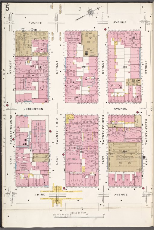
![Manhattan, V. 4, Plate No. 5 [Map bounded by 4th Ave., E. 25th St., 3rd Ave., E. 22nd St.]](https://images.nypl.org/index.php?id=1993025&t=b)
Lionel Pincus and Princess Firyal Map Division, The New York Public Library. "Manhattan, V. 4, Plate No. 5 [Map bounded by 4th Ave., E. 25th St., 3rd Ave., E. 22nd St.]" The New York Public Library Digital Collections. 1910. https://digitalcollections.nypl.org/items/94e2e0d6-8702-aebb-e040-e00a18063641
Lionel Pincus and Princess Firyal Map Division, The New York Public Library. "Manhattan, V. 4, Plate No. 5 [Map bounded by 4th Ave., E. 25th St., 3rd Ave., E. 22nd St.]" New York Public Library Digital Collections. Accessed April 19, 2024. https://digitalcollections.nypl.org/items/94e2e0d6-8702-aebb-e040-e00a18063641
Lionel Pincus and Princess Firyal Map Division, The New York Public Library. (1910). Manhattan, V. 4, Plate No. 5 [Map bounded by 4th Ave., E. 25th St., 3rd Ave., E. 22nd St.] Retrieved from https://digitalcollections.nypl.org/items/94e2e0d6-8702-aebb-e040-e00a18063641
<ref name=NYPL>{{cite web | url=https://digitalcollections.nypl.org/items/94e2e0d6-8702-aebb-e040-e00a18063641 | title=
(cartographic)
Manhattan, V. 4, Plate No. 5 [Map bounded by 4th Ave., E. 25th St., 3rd Ave., E. 22nd St.], (1910)
|author=Digital Collections, The New York Public Library |accessdate=April 19, 2024 |publisher=The New York Public Library, Astor, Lenox, and Tilden Foundations}}</ref>
![Manhattan, V. 4, Plate No. 5 [Map bounded by 4th Ave., E. 25th St., 3rd Ave., E. 22nd St.]](https://images.nypl.org/index.php?id=1993025&t=t)