


- The Library Shop
- Privacy Policy
- Rules and Regulations
- Using the Internet
- Website Terms and Conditions
- Gifts of Materials to NYPL
-
© The New York Public Library, 2024
The New York Public Library is a 501(c)(3) | EIN 13-1887440
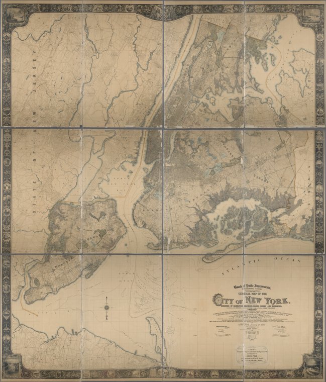
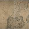
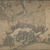
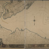
Lionel Pincus and Princess Firyal Map Division, The New York Public Library. "General map of the city of New York, consisting of boroughs of Manhattan, Brooklyn, Bronx, Queens and Richmond : consolidated into one municipality by act of the legislature of the state of New York (Chapter 378 of the laws of 1897) : showing in addition to the existing topographical and characteristic features of the city, a tentative and preliminary plan for a system of streets in those parts of the city consolidated under the above act of the legislature and which had no official street plan prior to 1898" The New York Public Library Digital Collections. 1900. https://digitalcollections.nypl.org/items/9e73fae8-2c67-d4b1-e040-e00a18062a71
Lionel Pincus and Princess Firyal Map Division, The New York Public Library. "General map of the city of New York, consisting of boroughs of Manhattan, Brooklyn, Bronx, Queens and Richmond : consolidated into one municipality by act of the legislature of the state of New York (Chapter 378 of the laws of 1897) : showing in addition to the existing topographical and characteristic features of the city, a tentative and preliminary plan for a system of streets in those parts of the city consolidated under the above act of the legislature and which had no official street plan prior to 1898" New York Public Library Digital Collections. Accessed April 23, 2024. https://digitalcollections.nypl.org/items/9e73fae8-2c67-d4b1-e040-e00a18062a71
Lionel Pincus and Princess Firyal Map Division, The New York Public Library. (1900). General map of the city of New York, consisting of boroughs of Manhattan, Brooklyn, Bronx, Queens and Richmond : consolidated into one municipality by act of the legislature of the state of New York (Chapter 378 of the laws of 1897) : showing in addition to the existing topographical and characteristic features of the city, a tentative and preliminary plan for a system of streets in those parts of the city consolidated under the above act of the legislature and which had no official street plan prior to 1898 Retrieved from https://digitalcollections.nypl.org/items/9e73fae8-2c67-d4b1-e040-e00a18062a71
<ref name=NYPL>{{cite web | url=https://digitalcollections.nypl.org/items/9e73fae8-2c67-d4b1-e040-e00a18062a71 | title=
(cartographic)
General map of the city of New York, consisting of boroughs of Manhattan, Brooklyn, Bronx, Queens and Richmond : consolidated into one municipality by act of the legislature of the state of New York (Chapter 378 of the laws of 1897) : showing in addition to the existing topographical and characteristic features of the city, a tentative and preliminary plan for a system of streets in those parts of the city consolidated under the above act of the legislature and which had no official street plan prior to 1898, (1900)
|author=Digital Collections, The New York Public Library |accessdate=April 23, 2024 |publisher=The New York Public Library, Astor, Lenox, and Tilden Foundations}}</ref>