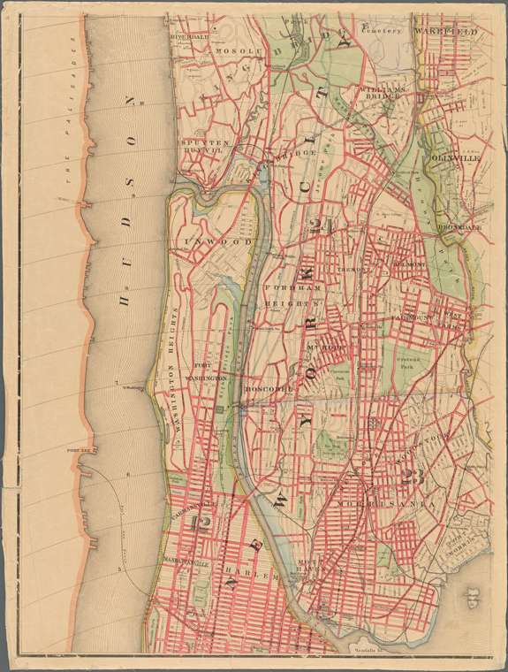
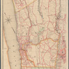
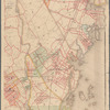
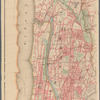
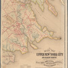
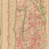
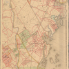
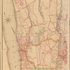
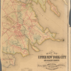
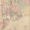
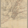
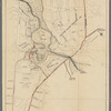
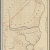
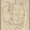
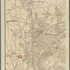
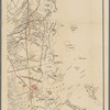
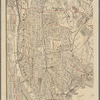
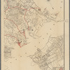
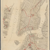
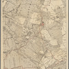
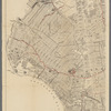
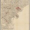
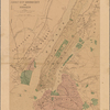
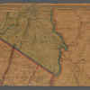
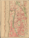
TitleMap of upper New York City and adjacent country: showing the city above 125th street : the city of Yonkers and townships of East Chester, West Chester, Pelham and New Rochelle, and a portion of Mamaroneck
NamesHyde & Company (Publisher)Collins, Morton (Civil engineer) (Surveyor)Bardner, Andrew (Surveyor)Hyde, Fred B. (Draftsman)Bord, Charles J. (Associated name)Burrowes, R. W. (Surveyor)Bracher, Wm. (William) (Engraver)Bourquin, F. (Frederick), 1808- (Printer)New York (N.Y.). Department of Parks (Surveyor)
CollectionMaps of New York City and State
New York City
New York City & Vicinity
Dates / OriginDate Issued: 1889Place: 48 Exchange Place, New YorkPublisher: Hyde & Company
Library locationsLionel Pincus and Princess Firyal Map DivisionShelf locator: Map Div. 16-6054
TopicsRailroads -- New York (State) -- New York Metropolitan AreaRoads -- New York (State) -- New York Metropolitan AreaLandowners -- New York (State) -- New York Metropolitan AreaNew York Metropolitan AreaBronx (New York, N.Y.)Yonkers (N.Y.)Eastchester (N.Y. : Town)Mount Vernon (Westchester County, N.Y.)Pelham (N.Y.)New Rochelle (N.Y.)
GenresMaps
NotesStatement of responsibility: compiled from plans made by actual surveys under the direction of the Chief Engineer at Department of Parks, the Chief Engineer of Yonkers, R.W. Burrowes, C.E. of Mount Vernon for the Towns of East Chester & West Chester, and also from valuable surveys owned by private individuals.Content: Shows railroads, opened and proposed streets & avenues, concentric half-mile circles from Grand Central Depot, parks, and some landownership.Content: Oriented with north to the upper left.Statement of responsibility: "Morton Collins, c.e., chief engineer & draughtsman ; Andrew Bardner, c.e., chief surveyor ; Fred B. Hyde, assistant draughtsman ; Chas. J. Bord, chief representative."Funding: Mapping the Nation (NEH grant, 2015-2018)
Physical DescriptionExtent: 1 map on 4 sheets : hand colored ; 158 x 116 cm, sheets 82 x 63 cm, or smaller
Type of ResourceCartographic
IdentifiersRLIN/OCLC: 946341418NYPL catalog ID (B-number): b20645881Other local Identifier: US172.3.01Universal Unique Identifier (UUID): 028b98b0-e54c-0133-2d90-00505686a51c
Rights StatementThe New York Public Library believes that this item is in the public domain under the laws of the United States, but did not make a determination as to its copyright status under the copyright laws of other countries. This item may not be in the public domain under the laws of other countries. Though not required, if you want to credit us as the source, please use the following statement, "From The New York Public Library," and provide a link back to the item on our Digital Collections site. Doing so helps us track how our collection is used and helps justify freely releasing even more content in the future.
Item timeline of events
-
-
-
-