


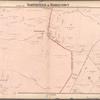
![Staten Island, V. 1, Plate No. 1 [Map bounded by Bank St., Westervelt Ave., York Ave.]](https://images.nypl.org/index.php?id=4028948&t=b)
![Staten Island, V. 1, Plate No. 2 [Map bounded by Westervelt Ave., Crescent Ave., Carlyle, York Ave.]](https://images.nypl.org/index.php?id=4028949&t=b)
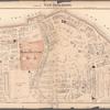
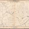
![Staten Island, V. 1, Plate No. 3 [Map bounded by Richmond Ter., Stuyvesant Pl., Westervelt Ave.]](https://images.nypl.org/index.php?id=4028950&t=b)
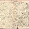
![Staten Island, V. 1, Plate No. 4 [Map bounded by New York Bay, Borough Pl., Richmond Ter.]](https://images.nypl.org/index.php?id=4028951&t=b)
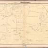
![Staten Island, V. 1, Plate No. 5 [Map bounded by Wall, St. Mark's Pl., Montgomery Ave., Benziger Ave., Sherman Ave.]](https://images.nypl.org/index.php?id=4028952&t=b)
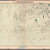
![Staten Island, V. 1, Plate No. 6 [Map bounded by Wall, Richmond Ter, Montgomery Ave.]](https://images.nypl.org/index.php?id=4028953&t=b)
![Staten Island, V. 1, Plate No. 7 [Map bounded by Benziger Ave., Montgomery Ave., Victory Blvd., Sherman Ave.]](https://images.nypl.org/index.php?id=4028954&t=b)
![Staten Island, V. 1, Plate No. 8 [Map bounded by Bay, Victory Blvd., Montgomery Ave.]](https://images.nypl.org/index.php?id=4028955&t=b)
![Staten Island, V. 1, Plate No. 9 [Map bounded by Victory Blvd., Bay, Hannah, Pavilion Hill Terrace]](https://images.nypl.org/index.php?id=4028956&t=b)
![Staten Island, V. 1, Plate No. 10 [Map bounded by Hannah, Bay, Grant, St. Paul;s Ave.]](https://images.nypl.org/index.php?id=4028957&t=b)
- The Library Shop
- Privacy Policy
- Rules and Regulations
- Using the Internet
- Website Terms and Conditions
- Gifts of Materials to NYPL
-
© The New York Public Library, 2024
The New York Public Library is a 501(c)(3) | EIN 13-1887440
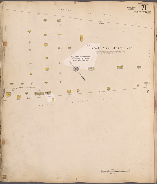
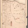
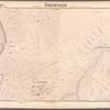
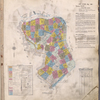
![Staten Island, V. 1, Plate No. 71 [Map of Pain's Fire Works Inc.]](https://images.nypl.org/index.php?id=4029018&t=b)
Insurance maps of Staten Island, Borough of Richmond, New York [1917]
Insurance maps of Staten Island, Borough of Richmond, New York, V. 1, updated to 1936
Lionel Pincus and Princess Firyal Map Division, The New York Public Library. "Staten Island, V. 1, Plate No. 71 [Map of Pain's Fire Works Inc.]" The New York Public Library Digital Collections. 1917. https://digitalcollections.nypl.org/items/bf791f80-7bf1-820b-e040-e00a1806237e
Lionel Pincus and Princess Firyal Map Division, The New York Public Library. "Staten Island, V. 1, Plate No. 71 [Map of Pain's Fire Works Inc.]" New York Public Library Digital Collections. Accessed April 25, 2024. https://digitalcollections.nypl.org/items/bf791f80-7bf1-820b-e040-e00a1806237e
Lionel Pincus and Princess Firyal Map Division, The New York Public Library. (1917). Staten Island, V. 1, Plate No. 71 [Map of Pain's Fire Works Inc.] Retrieved from https://digitalcollections.nypl.org/items/bf791f80-7bf1-820b-e040-e00a1806237e
<ref name=NYPL>{{cite web | url=https://digitalcollections.nypl.org/items/bf791f80-7bf1-820b-e040-e00a1806237e | title=
(cartographic)
Staten Island, V. 1, Plate No. 71 [Map of Pain's Fire Works Inc.], (1917)
|author=Digital Collections, The New York Public Library |accessdate=April 25, 2024 |publisher=The New York Public Library, Astor, Lenox, and Tilden Foundations}}</ref>
![Staten Island, V. 1, Plate No. 71 [Map of Pain's Fire Works Inc.]](https://images.nypl.org/index.php?id=4029018&t=t)