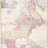
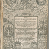
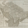
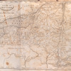
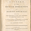
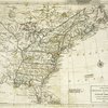
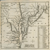
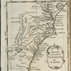
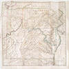
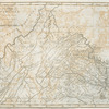
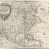
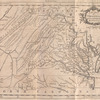
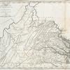
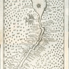
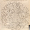
TitleModern geography: or all known countries in the world. : Laid down from the latest observations and discoveries, communicated to the Royal Society of London and Academy of Sciences at Paris. To which is added the geography of the ancient world, showing in six maps the Grecian and Roman Empires ... and in another map those parts of Africa which serve to illustrate ecclesiastic history
NamesSenex, John, -1740 (Cartographer)
CollectionLawrence H. Slaughter Collection of English maps, charts, globes, books and atlases
Atlases
Dates / OriginDate Issued: 1708 - 1725 (Inferred)Place: LondonPublisher: J. Senex
Library locationsLionel Pincus and Princess Firyal Map DivisionShelf locator: Map Div. 97-6057 [LHS 333; atlas cases]
TopicsEarly mapsGeography, Ancient
GenresMaps
NotesContent: A collection of Senex's sheet maps bound together.Content: Copy in Map Div. 97-6057 has pasted on back paste-down endpaper "A catalogue of globes, maps, & c. made by the late John Senex F.R.S. and continue to be sold by his widow, Mary Senex, at the Globe ..."Content: Copy in Map Div. 97-6057 has spine title: Senex maps.Content: Copy in Map Div. 97-6057 includes handwritten contents list on front paste-down endpaper. Three Moll maps listed, no. 7, 10, and 11, are wanting. No. 8 bound between no. 4 and 5.Content: Copy in Map Div. 97-6057: [54] folded leaves : 34 maps (most hand col.) ; 70 x 32 cm.Content: Copy in Map Div. cataloged in retrospective catalog under the title: [Collection of maps usually bound as part of A new general atlas engraved or revised by J. Senex]Content: Copy in Map Div. includes "A catalogue of the maps as they are placed in this book" (1 l.) and "A catalogue of globes, maps, & c. made by the late John Senex ... and continue to be sold by his widow, Mary Senex" (1 l.) inserted.Content: Lacks a t.p.Content: Lawrence H. Slaughter Collection ; 318 ; 333.Funding: National Endowment for the Humanities Grant for Access to Early Maps of the Middle Atlantic Seaboard.Date: Some maps have dates from 1708 to 1725, and some maps are without dates.Content: Title based on Phillips 550.Citation/reference: ESTC N62836Citation/reference: NYPL. Dictionary catalog of the Map Division, IX, p. 109Citation/reference: Phillips 550
Physical DescriptionExtent: 34 maps (33 col.) on 54 fold. leaves. 69 x 29 cm.
IdentifiersRLIN/OCLC: 16948217NYPL catalog ID (B-number): b13654254Universal Unique Identifier (UUID): e059c2e0-c5d3-012f-9f61-58d385a7bc34
Rights StatementThe New York Public Library believes that this item is in the public domain under the laws of the United States, but did not make a determination as to its copyright status under the copyright laws of other countries. This item may not be in the public domain under the laws of other countries. Though not required, if you want to credit us as the source, please use the following statement, "From The New York Public Library," and provide a link back to the item on our Digital Collections site. Doing so helps us track how our collection is used and helps justify freely releasing even more content in the future.
Item timeline of events
-
-
-