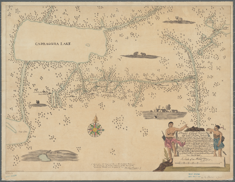
TitleA mappe of Colonel Römers voyage to ye 5 Indian Nations: going from New Yorck to Albany, thence west
Additional title: Map of Colonel Römers voyage to the Five Indian Nations
NamesRomer, Wolfgang William, 1640-1713 (Cartographer)Sims, Richard, 1816-1898 (Associated name)Moore, George Henry, 1823-1892 (Associated name)Hayward, George, approximately 1800- (Lithographer)
CollectionMaps of New York City and State
Whole
Dates / OriginDate Issued: 1834 - 1865 (Approximate)Place: New York, N.Y.?Publisher: publisher not identified
Library locationsLionel Pincus and Princess Firyal Map DivisionShelf locator: Map Div. 16-750
TopicsIndians of North America -- New York (State)Rivers -- New York (State)Lakes -- New York (State)New York (State)New York (State) -- History -- Colonial period, ca. 1600-1775Ontario, Lake (N.Y. and Ont.)
GenresMaps
NotesContent: Relief shown pictorially.Content: Covers most of New York state; includes land from east of the Hudson River to Cadragqua Lake (i.e. Lake Ontario).Content: Includes several vignettes depicting a traditional village, and indigenous animals, such as a turkey, a beaver and bears.Content: With "A Scale of 100 Miles" at lower right measuring 4 5/8 inches.Statement of responsibility: "Copied from the original ms. in the British Museum for Mr. George H. Moore, Librarian of the New York Historical Society, and compared by me. Richard Sims."Content: The title appears in an illustrated cartouche at lower right flanked by Native Americans in traditional dress.Content: "A Mappe of Colonel Römers Voyage to ye 5 Indian nations going from New Yorck to Albany thence west to ye 3 Macquas Castles and from ye last Castle called Daganahoge WSW towards Onyades a Second nation, and thence to ye Onnondages the third nation, & there I was Stoped & could not proced any forther for some important reassons & obliged to go from Onnondages to ye Lake of Cananda down Cananda River till we met Onnondages River & ye Osweges Riv. from whence we were to returne towards Onnondages having no provision & thence to Ononyedes & from thence to ye carring place wood kill & Bever kill & so to Oneyades agin & thence to Albany as it is set forth with read pricked lines; Anno do. 1700."Funding: Mapping the Nation (NEH grant, 2015-2018)
Physical DescriptionExtent: 1 map : hand colored ; 44 x 59 cm on sheet 48 x 61 cm
Type of ResourceCartographic
IdentifiersRLIN/OCLC: 613398415NYPL catalog ID (B-number): b21009811Other local Identifier: US136.4.03AUniversal Unique Identifier (UUID): ce0de150-34ad-0134-e9ec-00505686a51c
Rights StatementThe New York Public Library believes that this item is in the public domain under the laws of the United States, but did not make a determination as to its copyright status under the copyright laws of other countries. This item may not be in the public domain under the laws of other countries. Though not required, if you want to credit us as the source, please use the following statement, "From The New York Public Library," and provide a link back to the item on our Digital Collections site. Doing so helps us track how our collection is used and helps justify freely releasing even more content in the future.
Item timeline of events
-
-
-
-
-
-