Click to visit the main New York Public Library Homepage
The New York Public Library
Digital Collections
About Digital Collections
Browse
Search only public domain materials
Items
Collections
Divisions
Home
Search
Browse
About
Search only public domain materials
Items
Collections
Divisions
Digital Collections
Using Images
Using Data
Search
Keyword search
Show filters
Hide filters
Show Only Public Domain
topic
Railroads
27
Administrative and political divisions
17
Canals
13
History
5
Colonies
4
More
Less
name
Disturnell, John, 1801-1877
7
Sherman & Smith
7
Smith, J. Calvin (John Calvin)
7
Holland, Samuel, 1728-1801
4
Pownall, Thomas, 1722-1805
4
More
Less
collection
Maps of North America
33
Maps of New York City and State
20
I. N. Phelps Stokes Collection of American Historical Prints
15
Lawrence H. Slaughter Collection of English maps, charts, globes, books and atlases
10
John H. Levine Collection
3
More
Less
place
New York (State)
30
Québec (Province)
21
New England
15
Northeastern States
12
United States
12
More
Less
genre
Maps
68
Prints
14
Drawings
2
Clippings
1
Correspondence
1
More
Less
publisher
publisher not identified
7
J. Disturnell
4
E. Whitefield
3
M. A. Lotter
3
Publish'd by Laurie & Whittle, 53 Fleet Street
3
More
Less
division
Map Division
66
Wallach Division: Print Collection
16
Manuscripts and Archives Division
1
type
cartographic
67
still image
18
text
1
Date Range
to
83 results found for:
map quebec
Sort by:
Relevance
Title
Date created
Date digitized
Sequence
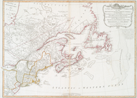
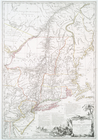
A general
map
of the middle British colonies
note:
… to Early
Maps
of the Middle
A general
map
of the northern British colonies
note:
… to Early
Maps
of the Middle
m
A
map
of Cabotia
note:
Map
borders Include "longitude west of Greenwich."…
A
map
of New England & ye country
note:
Mapping
the Nation (NEH grant, 2015-2018)…
A
map
of the British Empire in America …
note:
… --
Quèbec
-- New York
A
map
of the British Empire in America
note:
… --
Quebec
-- New York
A
map
of the country which
note:
Mapping
the Nation (NEH grant, 2015-2018)…
A
map
of the provinces of New-York
note:
LC
Maps
of North America, 1750-1789, 1048
A
map
of the provinces of New-York
note:
LC
Maps
of North America, 1750-1789, 1048
m
A
map
note:
LC
Maps
of North America, 1750-1789, 1048
A
map
of the United States and British
note:
… States, this
map
A new and accurate
map
of the English
note:
… to Early
Maps
of the Middle
A new and accurate
map
of the present war
note:
Mapping
the Nation (NEH grant, 2015-2018)…
…
map
of the British
note:
… to Early
Maps
of the Middle
…
map
of the British
note:
… to Early
Maps
of the Middle
…
map
of the British
note:
NYPL copy in
Map
Div. 01-5204: Ford
A new
map
of Upper & Lower Canada
note:
… to Early
Maps
of the Middle
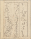
A topographical
map
of Hudsons River
note:
Mapping
the Nation (NEH grant, 2015-2018)…
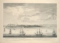
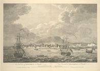
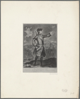
A view of the city of
Quebec
, the capital
A view of the city of
Quebec
, the capital
A view of the rivers Kenebec …
note:
Mapping
the Nation (NEH grant, 2015-2018)…
Accurata delineatio celeberri…
note:
Covers North America from
Quebec
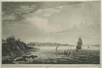
An east view of Montreal, in …
collection:
… and
maps
in the Stokes
Carte de la Nouvelle France: …
note:
Differs from similar
map
in dimensions
Carte de la Nouvelle France, …
abstract:
… similar
map
in dimensions
Carte du théatre de la guerre…
note:
… to Early
Maps
of the Middle
Carte du theatre de la guerre…
note:
Covers the area from
Quebec
to Cape May
Carte du théatre de la guerre…
note:
… to Early
Maps
of the Middle
Colton's new railroad & county
map
note:
…
Quebec
, and western New
m
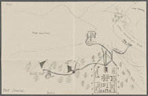
Drawing of campsite on the Li…
G. Woolworth Colton's series of railroad
maps
note:
Mapping
the Nation (NEH grant, 2015-2018)…
m
Lay's
map
of the United States
note:
… and
map
publisher
m
Lloyd's new county
map
of the United
note:
For Canada, covers southern
Quebec
and Ontario.
Lloyd's new
map
of the United States
note:
Includes list of other
maps
available
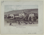
M'Gill College, Montreal.
collection:
… and
maps
in the Stokes
… against
Quebec
...
note:
…. Sayer,
map
& printseller
m
Map
of Lake Champlain
note:
… --
Map
of the Richelieu
Map
of Providence and Worcester R.R
note:
… York and
Quebec
.
Map
of Providence and Worcester R.R
note:
… York and
Quebec
.
Map
of the boundary lines between the United
note:
NYPL
Map
Div. copy
Map
of the country which was the scene
note:
Mapping
the Nation (NEH grant, 2015-2018)…
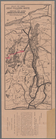
Map
of the eastern townships of Lower Canada
note:
Includes inset : Plan of
Quebec
(scale
Map
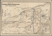
of the Fitchburg, Cheshire
note:
… southern Ontario and
Quebec
Map
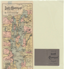
of the great pleasure route to Saratoga
note:
…
Quebec
to Albany.
Map
of the rail roads of the state
note:
… southern Ontario and
Quebec
.
Map
of the rail roads of the State
note:
… southern Ontario and
Quebec
.
Map
of the rail roads of the State
note:
Mapping
the Nation (NEH grant, 2015-2018)…
Map
of the routes through the middle
note:
… to Early
Maps
of the Middle
Map
of the routes through the middle
note:
… to Early
Maps
of the Middle
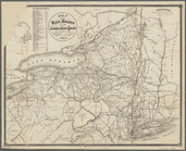
Map
of the state of New York
note:
Mapping
the Nation (NEH grant, 2015-2018)…