Click to visit the main New York Public Library Homepage
The New York Public Library
Digital Collections
About Digital Collections
Browse
Search only public domain materials
Items
Collections
Divisions
Home
Search
Browse
About
Search only public domain materials
Items
Collections
Divisions
Digital Collections
Using Images
Using Data
Search
Filtered search
Show filters
Hide filters
Show Only Public Domain
topic
History
2735
Clothing & dress
1719
Women
1264
Slavery
594
Theater
527
More
Less
name
Geographical Surveys West of the 100th Meridian (U.S.)
341
E. & H.T. Anthony (Firm)
290
DeBevoise, C. Manley
251
Van Vechten, Carl, 1880-1964
249
O'Sullivan, Timothy H., 1840-1882
246
More
Less
collection
Wallach Division Picture Collection
3141
"The Pageant of America" Collection
1764
Robert N. Dennis collection of stereoscopic views
1529
Photographic views of the United States
949
Maps of North America
418
More
Less
place
x
United States
New York (State)
977
Washington (D.C.)
556
New York
341
Long Island (N.Y.)
312
More
Less
genre
Photographs
5265
Prints
3075
Stereographs
1541
Illustrations
991
Maps
741
More
Less
publisher
J. Dobson
153
Taylor & Huntington
120
John F.Jarvis
94
Cleveland, O
88
A. Bertrand
81
More
Less
division
Wallach Division: Photography Collection
3556
Wallach Division: Picture Collection
2343
Milstein Division
971
Map Division
699
Manuscripts and Archives Division
532
More
Less
type
still image
10253
text
1375
cartographic
723
notated music
54
moving image
19
More
Less
Date Range
to
11,756 results found
Filtering on:
x
Date
: 1653 - 1894
x
Place
: United States
Sort by:
Title
Date created
Date digitized
Sequence
Results 2251 - 2300
Pictorial map of the seat of …
Ocilla River, Florida
Sketch G : showing the progre…
Map of the Yellowstone Nation…
m
Map of the Yellowstone Nation…
Official stationery of the Ca…
k
Interview with Margot Webb, 1…
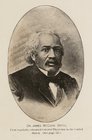
Dr. James McCune Smith, first…
m
The Horace Greeley campaign s…
m
Map of part of Virginia, Mary…
Map of eastern Virginia : com…
Plan of Amelia Island in East…
Plan of the French and Americ…
New map of Charleston Harbor:…
An accurate map of North and …
A new map of Carolina
Johnson's North Carolina and …
Plan of the siege of Charlest…
[Maps of the Washington Aqued…
[Rivers, county maps of the s…
m
Garfield and Arthur Republica…
The presidents of the United …
m
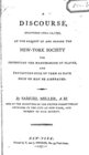
A discourse, delivered April …
Military map of south-eastern…
Military map of south-eastern…
Albemarle and Chesapeake Cana…
Map of the vicinity of Richmo…
m
Supervisors districts elevent…
Statistical map of the United…
Rand McNally & Co.'s new offi…
Rand McNally & Co.'s new offi…
m
Rand, McNally and Co.'s gener…
Gen. Washington's Revolutiona…
Studio photo of Loie Fuller h…
Preliminary chart of Port Roy…
Map of Richmond, Virginia, an…
Plan of the siege of York Tow…
m
Catt, Carrie Chapman
m
Hopkins
South-Carolina and parts adja…
A plan of the attack of Fort …
Sketch of the battle of Hobki…
m
An accurate map of North and …
Seat of war in Virginia : she…
Strategic war points of the U…
m
Survey of the Allegheny River…
m
A new description of Carolina
Plan of the battle fought nea…
Solomon Carter Fuller in his …
Meta Warrick Fuller in her li…
1
2
…
7
8
9
10
11
12
13
14
…
47
48
Previous
Next
1
2
…
7
8
9
10
11
12
13
14
…
47
48
Previous
Next