Click to visit the main New York Public Library Homepage
The New York Public Library
Digital Collections
About Digital Collections
Browse
Search only public domain materials
Items
Collections
Divisions
Home
Search
Browse
About
Search only public domain materials
Items
Collections
Divisions
Digital Collections
Using Images
Using Data
Search
Filtered search
Show filters
Hide filters
Show Only Public Domain
topic
x
Maps
Landowners
25
Real property
25
Early works to 1800
5
Administrative and political divisions
3
More
Less
name
Homann, Johann Baptist, 1663-1724
37
Chauchard, Captain
28
Gillet, Thomas
28
Neele, Samuel John, 1758-1824
28
Stockdale, John, 1749?-1814
28
More
Less
collection
Atlases, gazetteers, guidebooks and other books
70
Maps of North America
36
Maps of New York City and State
4
place
Switzerland
37
Italy
36
Europe
28
New Jersey
25
Mercer County (N.J.)
4
More
Less
genre
Maps
110
Manuscript maps
26
Surveys
25
Atlases
3
Nautical charts
2
publisher
Printed for John Stockdale, Piccadilly. T. Gillett, Printer, Salisbury Square
28
Printed for Robt. Sayer & Jno. Bennett
2
Chez Le Rouge, Ingr. Geog du Roi rue des Grands Augustins
1
Dan Paterson
1
Fielding and Walker?
1
More
Less
division
x
Map Division
type
cartographic
107
text
4
Date Range
to
110 results found
Filtering on:
x
Date
: 1700 - 1800
x
Division
: Map Division
x
Rights
: Public Domain
x
Topic
: Maps
Sort by:
Title
Date created
Date digitized
Sequence
Map of New Haven and its envi…
An exact map of the five grea…
A new map of the Cherokee Nat…
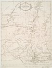
Part of North America, contai…
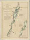
A survey of Lake Champlain: i…
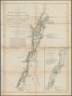
A survey of Lake Champlain: i…
Distribution of his majesty's…
A map of part of the N. W. Te…
Carte contenant le royaume du…
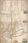
An accurate map of the Distri…
A map of the district of Main…
m
M. Stacy 1000 a. (survey of M…
m
Draughts of land in Amwell in…
m
A plan of 8 acres land survey…
m
Jon. Biddle's draught on Assu…
m
Coll. John Bryerly's draught …
m
Benjn. Field's surveys (of 17…
m
Jon. Jewel's draught for 105 …
m
Draught of 8 3/4 acres of lan…
m
Draught of 1855 acres lying u…
m
Saml. Devenport & Elizath. Ro…
m
Charls Reed's survey & draugh…
m
Draught of Gidion's Bickerdik…
m
James Freese's mapp of his lo…
m
Coppy of M. Stacys survey, 13…
m
Mahlon Wright's draft of 86 a…
m
John Biddle's survey of 472 a…
m
John Biddle's survey of 219 a…
m
Saml. Devenports draught & su…
m
Saml. Devenports tract as ye …
m
Jos. Kirkbrid's 1250 acre tra…
m
Copy of the return of Joseph …
m
Return of land joyning to Tho…
m
Return of three tract of pine…
m
Isaac Watson resurvey, 1724 (…
m
Saml. Devenports mapp of his …
A general map of the southern…
An Accurate map of New York i…
Province de New-York : en 4 f…
Map of the southern provinces…
La Pologne, Plate 19
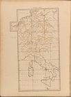
Index Map
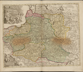
A general map of the empire o…
To the King's Most Excellent …
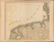
Plate I: A general map of the…
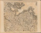
Plate II: A general map of th…
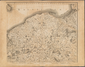
Plate III: A general map of …
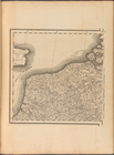
Plate IV: A general map of t…
Plate V: A general map of the…
Plate VI: A general map of th…