Click to visit the main New York Public Library Homepage
The New York Public Library
Digital Collections
About Digital Collections
Browse
Search only public domain materials
Items
Collections
Divisions
Home
Search
Browse
About
Search only public domain materials
Items
Collections
Divisions
Digital Collections
Using Images
Using Data
Search
Filtered search
Show filters
Hide filters
Show Only Public Domain
topic
Nautical charts
3
Harbors
2
Early maps
1
name
W. & J. Mount & T. Page
2
Moll, Herman, -1732
1
Salmon, Thomas, 1679-1767
1
Stephens
1
T. Page and W. Mount
1
More
Less
collection
Lawrence H. Slaughter Collection of English maps, charts, globes, books and atlases
2
Africa secondo le ultime osservazioni dell'Academia Reale delle Scienze de Parigi
1
John H. Levine Collection
1
Maps of North America
1
Printed maps of Russia and neighboring lands, including city plans of Saint Petersburg, from the 17th to the early20th century]
1
place
New York (N.Y.)
2
New York Harbor (N.Y. and N.J.)
2
New York Region
2
Atlantic Coast (North America)
1
Black Sea
1
More
Less
genre
x
Maps
publisher
Printed for & sold by Page & Mount on Tower Hill
1
Printed for W. Mount & T. Page
1
Royal Academy of Science
1
Sold by Willm. Mount & Tho. Page at the Postern on Great Tower Hill
1
Printed for Thomas Salmon and sold by J. Roberts?
1
division
Map Division
4
Rare Book Division
1
Schomburg Jean Blackwell Hutson Research and Reference Division
1
type
cartographic
6
Date Range
to
6 results found
Filtering on:
x
Date
: 1737 - 1737
x
Genre
: Maps
Sort by:
Title
Date created
Date digitized
Sequence
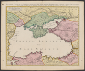
Nouvelle carte de la Crimée &…
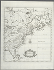
A map of the British-plantati…
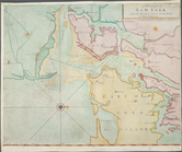
A draught of New York from th…
A chart of the sea coast of N…
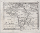
Africa secondo le ultime osse…
A draught of New York from th…