Click to visit the main New York Public Library Homepage
The New York Public Library
Digital Collections
About Digital Collections
Browse
Search only public domain materials
Items
Collections
Divisions
Home
Search
Browse
About
Search only public domain materials
Items
Collections
Divisions
Digital Collections
Using Images
Using Data
Search
Filtered search
Show filters
Hide filters
Show Only Public Domain
topic
Geography
141
History
92
Road maps
54
Nautical charts
50
Atlases, British
44
More
Less
name
Sayer, Robert, 1725-1794
61
Tiebout, Cornelius, 1777-1832
61
Colles, Christopher, 1738-1816
53
Cary, John, approximately 1754-1835
47
Faden, William, 1749-1836
46
More
Less
collection
Bancker plans
623
Lawrence H. Slaughter Collection of English maps, charts, globes, books and atlases
283
Maps of North America
188
Atlases, gazetteers, guidebooks and other books
70
Maps of New York City and State
46
More
Less
place
United States
153
Middle Atlantic States
75
North America
73
Great Britain
72
Maps
59
More
Less
genre
x
Maps
Surveys
622
land surveys
539
Documents
87
Prints
33
More
Less
publisher
Printed for John Cary
47
Printed for Robert Sayer, No. 53, Fleet-Street
44
Printed for J. Stockdale
25
publisher not identified
24
Imprimé à l'Université Imperiale de Moscou
22
More
Less
division
Manuscripts and Archives Division
631
Map Division
626
Rare Book Division
42
Wallach Division: Print Collection
28
General Research Division
14
More
Less
type
cartographic
1354
text
160
still image
10
Date Range
to
1,360 results found
Filtering on:
x
Date
: 1766 - 1794
x
Genre
: Maps
Sort by:
Title
Date created
Date digitized
Sequence
Results 501 - 550
m
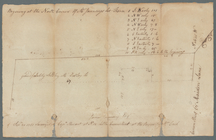
Ground on Golden Hill owned b…
m
Heirs of Mr. Brassee's house …
m
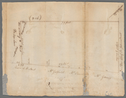
The late John Hopper's farm a…
m
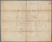
Hopper Farm, showing divisions
m
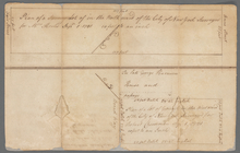
Plot of farm bounded by N. Ri…
m
Benjamin Booth's lot north si…
A map of the province of Mass…
m
Captain De Lancey's ground
To His Excellency Genl. Washi…
To his excellency Genl Washin…
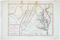
Carte de la Virginie, du Mary…
Carte du theatre de la guerre…
Carte du théatre de la guerre…
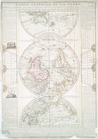
Carte generale de la terre : …
Carte de l'Amérique septentri…
Carte de la Louisiane et du c…
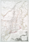
Carte generale des treize Eta…
Carte de la Louisiane et du c…
m
Plano.: de la Ysla de Sn. Jua…
m
Piece of Church ground leased…
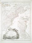
Chart and plan of the harbour…
Chart and plan of the harbour…
m
Lot in Princess Street
m
Carr's ground in Beaver Street
m
North side of Beaver Street
m
Plan of lots number one to fo…
m
Lot in Crown Street or Maiden…
m
Golden Hill and Van Clyff's S…
m
Ground between William and Jo…
m
Broadway, Anne and Fair Stree…
m
Hester Pell's lot in Broad St…
m
Dr. Charleton's ground in Lum…
m
Norfolk, Suffolk, Division, a…
m
Lot in Broad Street
m
Frankfort and Kip Streets
m
Kip Street
m
Meyer's lot in Fair Street
m
Mr. Milliner's lots between d…
m
South west side of Little Que…
m
Ground commonly called Degrus…
m
Two lots east side Broad Stre…
m
Mr. Cook's lot on the north s…
m
Six acres of land near Great …
m
Sketch of the vineyard
m
Lot near Jewish burying ground
m
Mr. Marston's three lots on G…
m
Erroneous draft of Marston's …
m
James Delancey's lot and old …
m
Survey of the Old House near …
m
John Dudley's two lots in Mai…
1
2
3
4
5
6
Previous
Next
1
2
3
4
5
6
Previous
Next