Click to visit the main New York Public Library Homepage
The New York Public Library
Digital Collections
About Digital Collections
Browse
Search only public domain materials
Items
Collections
Divisions
Home
Search
Browse
About
Search only public domain materials
Items
Collections
Divisions
Digital Collections
Using Images
Using Data
Search
Filtered search
Show filters
Hide filters
Show Only Public Domain
topic
History
56
Nautical charts
31
Administrative and political divisions
15
Description and travel
15
Long Island, Battle of, New York, N.Y., 1776
12
More
Less
name
Faden, William, 1749-1836
26
Robert Sayer and John Bennett (Firm)
18
Kitchin, Thomas, 1718-1784
17
Lotter, Matthäus Albrecht, 1741-1810
12
Lotter, Tobias Conrad, 1717-1777
12
More
Less
collection
Bancker plans
173
Lawrence H. Slaughter Collection of English maps, charts, globes, books and atlases
82
Maps of North America
82
Maps of New York City and State
38
I. N. Phelps Stokes Collection of American Historical Prints
15
More
Less
place
New York (N.Y.)
43
North America
42
New York (State)
34
United States
32
New Jersey
31
More
Less
genre
Maps
421
Surveys
173
land surveys
140
Documents
33
Prints
15
More
Less
publisher
publisher not identified
13
Presso Antonio Zatta
12
The translator
10
s.n
8
Tobias Conrad Lotter?
5
More
Less
division
Map Division
216
Manuscripts and Archives Division
176
Wallach Division: Print Collection
18
General Research Division
12
Rare Book Division
3
More
Less
type
x
cartographic
text
38
still image
5
Date Range
to
428 results found
Filtering on:
x
Date
: 1770 - 1779
x
Type
: cartographic
Sort by:
Title
Date created
Date digitized
Sequence
Pennsylvania - Paoli, Chester…
A chorographical map of the P…
Det gamle Norge
A new map of North America fr…
A plan of Captain Carvers tra…
A compleat map of North-Carol…
Grundriss des nördlichen Thei…
Plan von den Operationen der …
A plan of New York Island, pa…
Chart of the coast of Georgia
Plan of the entrance into Cap…
The harbour of Charles Town i…
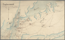
Emplacement des troupes en qu…
Plan der Attaque, welche Sr. …
A plan of the harbour of St. …
m
Bedlow's Island
m
Bayard Street
m
Lot on Bloomingdale Road
m
Bloomingdale Road
m
Battery
m
A map of the most inhabited p…
A sketch of the Cherakee boun…
Plan of Amelia Island in East…
A plan of Charles Town, the c…
An accurate map of North and …
A new and accurate map of the…
A new and accurate map of Nor…
A plan of the several village…
m
Great Dock
m
John Thurman's lots - Wall St…
m
Wall Street, Broad Street to …
m
Mr. Lawrence Read's house in …
m
Swamp
m
Stone Street
m
Queen and Rutgers Street
m
Queen Street
m
Leonard Lispenard's two lots …
m
New Quaker meeting lot
m
Peck's Slip ferry stairs
m
Griswold's encroachment
m
Smith's Slip
m
Phillip Van Courtland's in Na…
m
Nassau Island ferry wharf
m
Anthony Rutger's Brewery
m
Map of Kip's Bay
m
Sugar House
m
Harlem Line
m
Hanover Square and Dock Street
m
Now Ireland's, formerly schoo…
m
Anthony Rutgers's land and Ch…
1
2
Previous
Next
1
2
Previous
Next