Click to visit the main New York Public Library Homepage
The New York Public Library
Digital Collections
About Digital Collections
Browse
Search only public domain materials
Items
Collections
Divisions
Home
Search
Browse
About
Search only public domain materials
Items
Collections
Divisions
Digital Collections
Using Images
Using Data
Search
Filtered search
Show filters
Hide filters
Show Only Public Domain
topic
History
60
Description and travel
44
Antiquities
40
Nautical charts
35
Archaeological sites
21
More
Less
name
Norden, Frederik Ludvig, 1708-1742
40
Tuscher, Markus, 1705-1751
40
Faden, William, 1749-1836
34
Robert Sayer and John Bennett (Firm)
18
Kitchin, Thomas, 1718-1784
16
More
Less
collection
Bancker plans
173
Maps of North America
101
Lawrence H. Slaughter Collection of English maps, charts, globes, books and atlases
81
Maps of New York City and State
41
The antiquities, natural history, ruins and other curiosities of Egypt, Nubia and Thebes. Exemplified in near two hundred drawings taken on the spot
40
More
Less
place
New York (N.Y.)
42
New York (State)
42
Egypt
40
North America
37
United States
37
More
Less
genre
Maps
439
Surveys
173
land surveys
144
Prints
56
Illustrations
41
More
Less
publisher
Printed for Lockyer Davis
40
publisher not identified
13
Presso Antonio Zatta
12
J. Hinton
8
s.n
7
More
Less
division
Map Division
239
Manuscripts and Archives Division
177
General Research Division
41
Wallach Division: Print Collection
16
Rare Book Division
2
More
Less
type
x
cartographic
text
35
still image
6
Date Range
to
480 results found
Filtering on:
x
Date
: 1775 - 1780
x
Type
: cartographic
Sort by:
Title
Date created
Date digitized
Sequence
Pennsylvania - Paoli, Chester…
A chorographical map of the P…
A new map of North America fr…
A plan of Captain Carvers tra…
m
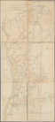
Map of the East Side of the N…
Plan of the position which th…
Grundriss des nördlichen Thei…
Plan von den Operationen der …
A plan of New York Island, pa…
Chart of the coast of Georgia
Plan of the entrance into Cap…
The harbour of Charles Town i…
m
A sketch of the operations be…
A sketch of the environs of C…
A sketch of the environs of C…
A sketch of the environs of C…
Chart of the N.W. coast of Am…
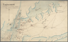
Emplacement des troupes en qu…
Plan der Attaque, welche Sr. …
A plan of the harbour of St. …
m
Draft of square B of James De…
m
Plan of Mr. Mott and Mr. Sawy…
m
Quantity of lots in the unequ…
m
Measurement of De Lancey's gr…
m
Alderman Dykeman's land betwe…
m
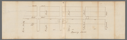
Plot on Bowery lane
m
Webber and Van Arden
m
Lots near Amity Street, Broad…
m
Battery
m
A map of the most inhabited p…
A plan of Charles Town, the c…
An accurate map of North and …
A new and accurate map of the…
A New and accurate map of the…
A new and accurate map of the…
A new and accurate map of Nor…
A plan of the several village…
m
Lot of Mr. Edward Laight in W…
m
Between Lispenard and Leonard…
m
Harlem Creek
m
Colonel Magregor's at Greenwi…
m
Greenwich Street between Dyes…
m
College ground and lots
m
Malleshaw's near Fresh Water
m
Cockraft's lot facing the Fly…
m
Dock Street
m
Corlear's Hook - soil and wat…
m
Sketches showing grades and d…
m
circa 1780-1785
m
Map of Little Bloomingdale
1
2
Previous
Next
1
2
Previous
Next