Click to visit the main New York Public Library Homepage
The New York Public Library
Digital Collections
About Digital Collections
Browse
Search only public domain materials
Items
Collections
Divisions
Home
Search
Browse
About
Search only public domain materials
Items
Collections
Divisions
Digital Collections
Using Images
Using Data
Search
Filtered search
Show filters
Hide filters
Show Only Public Domain
topic
Geography
114
Historical geography
57
Maps in education
56
Road maps
54
Atlases
53
More
Less
name
Faden, William, 1749-1836
75
Tiebout, Cornelius, 1777-1832
63
Stockdale, John, 1749?-1814
54
Colles, Christopher, 1738-1816
53
Sayer, Robert, 1725-1794
47
More
Less
collection
Bancker plans
579
Lawrence H. Slaughter Collection of English maps, charts, globes, books and atlases
264
Maps of North America
136
Atlases, gazetteers, guidebooks and other books
88
The antiquities, natural history, ruins and other curiosities of Egypt, Nubia and Thebes. Exemplified in near two hundred drawings taken on the spot
40
More
Less
place
United States
129
Great Britain
103
England
86
Middle Atlantic States
62
Egypt
42
More
Less
genre
Maps
1272
Surveys
578
land surveys
510
Documents
74
Prints
64
More
Less
publisher
Published by Wm. Faden, geographer to His Majesty, and His R.H. the Prince of Wales
53
Printed for Robert Sayer, No. 53, Fleet-Street
44
Printed for John Cary
43
Printed for Lockyer Davis
40
Chez Delamarche
30
More
Less
division
Manuscripts and Archives Division
588
Map Division
549
General Research Division
79
Pforzheimer Collection
32
Rare Book Division
19
More
Less
type
x
cartographic
text
136
still image
8
Date Range
to
1,313 results found
Filtering on:
x
Date
: 1780 - 1800
x
Type
: cartographic
Sort by:
Title
Date created
Date digitized
Sequence
m
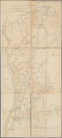
Map of the East Side of the N…
Townships of Franklin and Som…
Sketch of the Northern Part o…
A general sketch of the Harbo…
A map of Barbary comprehendin…
From New York (1) to Stratford
m
Plano.: de la Ysla de Sn. Jua…
Karta Shelekhova. Stranstvova…
A1
Plan of Conewago Canal
m
Lots on the north east side o…
m
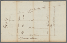
Anne Street
A map of the world from the b…
m
Lots near Amity Street, Broad…
m
Webber and Van Arden
m
Map of Little Bloomingdale
A map of Dutch settlements of…
m
Bloomingdale
m
Thomas Cadle's land at Bloomi…
m
Richard Cunningham's ground a…
m
Plan of twelve acres on the e…
m
Plot of farm bounded by N. Ri…
m
Hopper Farm, showing divisions
m
The late John Hopper's farm a…
m
Homestead at Bloomingdale
m
Two tracts of land at Bloomin…
m
John Wilkes's five acre lot a…
m
Phillip Webber's land between…
m
Phillip Webber's two tracts o…
m
Map of part of the late Jacob…
m
Van Arden, Warner and John Ke…
m
Bloomingdale
m
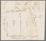
Bloomingdale Road
m
Survey of the two pieces of l…
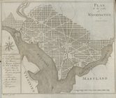
Plan de la ville de Washingto…
m
circa 1780-1785
m
circa 1780-1785
m
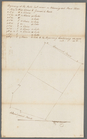
Plot on Bowery lane
m
Bowery Lane and King's Bridge…
m
Potters field
m
Lots on the Bowery and Mott S…
m
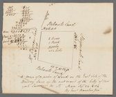
Lot near Jewish burying ground
m
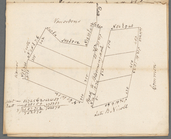
Lots on Bowery Lane
m
The mansion of Captain De Lan…
m
Ground on the east side of Bo…
m
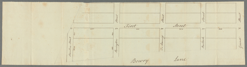
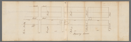
Bowery Lane
m
Ground lying on the east side…
m
Parcel of land in the Bowery
m
Brevoort, Smith and Dawson's …
m
Mathew Buys land in five equa…
1
2
3
4
5
6
Previous
Next
1
2
3
4
5
6
Previous
Next