Click to visit the main New York Public Library Homepage
The New York Public Library
Digital Collections
About Digital Collections
Browse
Search only public domain materials
Items
Collections
Divisions
Home
Search
Browse
About
Search only public domain materials
Items
Collections
Divisions
Digital Collections
Using Images
Using Data
Search
Filtered search
Show filters
Hide filters
Show Only Public Domain
topic
Atlases, British
31
Geography
31
History
6
Maps in education
3
World maps
2
More
Less
name
Sayer, Robert, 1725-1794
33
Dunn, Samuel, d. 1794
31
Brion de la Tour, Louis, -1823
3
Brion de la Tour, Louis, 1743-1803
3
Desnos, Louis-Charles, 1725-1805
3
More
Less
collection
Bancker plans
39
Atlases, gazetteers, guidebooks and other books
32
Lawrence H. Slaughter Collection of English maps, charts, globes, books and atlases
13
Maps of North America
10
Africa: with all its states, kingdoms, republics, regions, islands, &ca., improved and inlarged from D'Anville's map; to which have been added a particular chart of the Gold Coast wherein are distinguished all the European forts and factories
1
More
Less
place
United States
8
Early works to 1800
7
Maps
7
North America
6
France
4
More
Less
genre
Maps
96
Surveys
39
land surveys
35
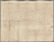
Documents
4
publisher
Printed for Robert Sayer, No. 53, Fleet-Street
31
Buisson,
3
publisher not identified
3
Chez Brocas
2
Chez Desnos, ingr. geographe ..
2
More
Less
division
Map Division
56
Manuscripts and Archives Division
39
Schomburg Jean Blackwell Hutson Research and Reference Division
1
type
x
cartographic
text
8
Date Range
to
96 results found
Filtering on:
x
Date
: 1786 - 1787
x
Type
: cartographic
Sort by:
Title
Date created
Date digitized
Sequence
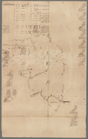
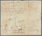
Amerika ĕst nor Ashkharhagrak…
Plan of the siege of Charlest…
Plan of the remains of some a…
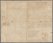
m
Lots on the Bowery and Mott S…
A map of the country between …
m
Mr. Skullthorp's three lots i…
m
Nassau and John Streets
m
Two pieces of ground at Harlem
m
Land at Harlem
m
Ground near Fresh Water
m
East River to Dock Street
m
Andrew Van Horne's land, Berg…
m
Land, meadow, and mill pond e…
m
Mill at Gowanus
m
Mr. Barns's land at Westchest…
m
Minutes of Mr. Carley's land …
m
Horn's Hook for Abraham Duria
m
Draft of the estate of the la…
m
Thomas Barn's land at Westche…
m
Samuel Bayard's ground near t…
m
Brevoort, Smith and Dawson's …
m
Frankfort Street lots of Mr. …
m
Corner of Queen and Beekman S…
m
Princess Street
m
East side of Peck's Slip
m
Pearl Street
m
Corner of Nassau and Maiden L…
m
Evaluation of W. Blaau's esta…
m
Water lots from Mr. Desbrosse…
m
Wall Street
m
John Antonide's land at Flatb…
m
Thomas Barns's land Westchest…
m
Barclay and Greenwich Streets
m
Fly Market
m
Seaman and Constable at Cruge…
m
Cherry Street
m
Four lots of ground in Cherry…
m
Corner Bridge street and Broa…
m
Bounds of Mr. Richard's lot a…
m
Ryker's lots, east side of Bu…
m
Evert Wessel and Peter Van Be…
m
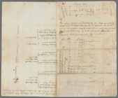
Computation of lands between …
m
Jane Montgomery's square numb…
Plan of the siege of York Tow…
Plan of the battle fought nea…
The marches of Lord Cornwalli…
Annual passage of the herring…
Carte réduite du Nord des Eta…
Carte réduite du Sud des État…
Carte d'une partie de l'Améri…