Click to visit the main New York Public Library Homepage
The New York Public Library
Digital Collections
About Digital Collections
Browse
Search only public domain materials
Items
Collections
Divisions
Home
Search
Browse
About
Search only public domain materials
Items
Collections
Divisions
Digital Collections
Using Images
Using Data
Search
Filtered search
Show filters
Hide filters
Show Only Public Domain
topic
Real property
7278
Fire insurance
4039
Cities & towns
3829
Administrative and political divisions
869
Railroads
717
More
Less
name
Sanborn Map Company
3830
Beers, F. W. (Frederick W.)
588
E. Robinson Co
385
Ullitz, Hugo
378
E.B. Hyde & Co
356
More
Less
collection
Atlases of New York City
6009
Maps of North America
2929
Atlases of the United States
2920
Maps of New York City and State
1618
Bancker plans
496
More
Less
place
New York (State)
8073
New York
1801
New York (N.Y.)
1011
Manhattan (New York, N.Y.)
852
Brooklyn (New York, N.Y.)
837
More
Less
genre
Maps
15568
Atlases
2861
Cadastral maps
562
Surveys
556
land surveys
442
More
Less
publisher
Sanborn Map Company
3958
publisher not identified
416
E. Robinson Co
297
E. Belcher Hyde
265
G.W. Bromley & Co
246
More
Less
division
Map Division
14228
Manuscripts and Archives Division
557
General Research Division
344
Rare Book Division
156
Schomburg Jean Blackwell Hutson Research and Reference Division
87
More
Less
type
x
cartographic
text
345
still image
209
Date Range
to
15,771 results found
Filtering on:
x
Date
: 1793 - 1906
x
Type
: cartographic
Sort by:
Title
Date created
Date digitized
Sequence
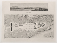
1. Grundriss des Ammontempels…
1. Ruines d'un temple d'Ysis …
1. Vue de Thèbes. 2. Plan du …
m
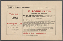
10 Bronx Plots suitable for B…
101st St. & 102nd St. and the…
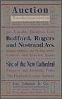
10th ward, Jewish Quarter...
m
12,000 Square Miles around Ne…
13 lots of ground to be sold …
m
1793 August 14
m
1793 August 14
m
1793 March 10
m
1793 March 18
180 lots on the Marsellis Tra…
m
1800 October 29
m
1800 October 29
m
1800 October 29
m
1801 December 21
m
1801 December 21
m
1803 April 6
m
1810 January 7
m
1810 January 8
1841, showing the dates of th…
1863, West Point: [New York]
1889, Larchmont Harbor, N.Y.:…
1892 Tallapoosa, Ga., Haralso…
1892, Harrison's map of Jerse…
m
1896 Connecticut River, Conn.…
1899 Railroad map of Ohio
m
1905 Library map of Manhattan…
m
1906 Library map of Manhattan…
1st & 2nd Wards. [Map bounded…
1st & 3rd Wards. [Map bounded…
1st Ward of NYC: [in draft du…
1st Ward. [Map bounded by Bow…
1st Ward. [Map bounded by Exc…
1st Ward. [Map bounded by Lib…
1st Ward. [Map bounded by Sto…
1st Ward. [Map bounded by Wes…
m
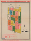
20th ward.
m
27th assembly district
2nd & 4th Wards. [Map bounded…
2nd Ward. [Map bounded by Bro…
2nd Ward. [Map bounded by Pea…
2nd Ward. [Map bounded by Wil…
m
3 three story brick houses in…
m
301 Valuable Brooklyn Lots Be…
m
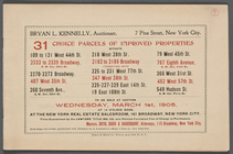
31 Choice Parcels of Improved…
m
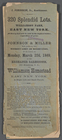
320 Splendid Lots. Williamson…
m
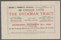
33 Choice Lots situate [sic] …
3rd Ward. [Map bounded by Col…
1
2
3
4
5
6
7
8
9
10
…
63
64
Previous
Next
1
2
3
4
5
6
7
8
9
10
…
63
64
Previous
Next