Click to visit the main New York Public Library Homepage
The New York Public Library
Digital Collections
About Digital Collections
Browse
Search only public domain materials
Items
Collections
Divisions
Home
Search
Browse
About
Search only public domain materials
Items
Collections
Divisions
Digital Collections
Using Images
Using Data
Search
Filtered search
Show filters
Hide filters
Show Only Public Domain
topic
x
Real property
Fire insurance
3191
Cities & towns
3086
Business enterprises
468
Landowners
278
More
Less
name
Sanborn Map Company
3086
Beers, F. W. (Frederick W.)
355
Perris, William
260
D.G. Beers & Co
161
Beers, D. G. (Daniel G.)
153
More
Less
collection
Atlases of New York City
3630
Atlases of the United States
1243
Maps of North America
223
Maps of New York City and State
186
Maps of property in the city of New York belonging to John J. Astor Esq
1
place
New York (State)
4905
New York
557
Manhattan (New York, N.Y.)
272
Brooklyn (New York, N.Y.)
175
Erie County
151
More
Less
genre
Maps
5104
Atlases
1240
Cadastral maps
280
Prints
69
Title pages
36
More
Less
publisher
Sanborn Map Company
3086
F. W. Beers & Co
148
Perris & Browne
124
G.M. Hopkins & Co
108
William Perris
105
More
Less
division
Map Division
5152
No Division
1
type
cartographic
5166
text
135
still image
26
Date Range
to
5,283 results found
Filtering on:
x
Date
: 1838 - 1885
x
Topic
: Real property
Sort by:
Title
Date created
Date digitized
Sequence
1st & 2nd Wards. [Map bounded…
1st & 3rd Wards. [Map bounded…
1st Ward. [Map bounded by Bow…
1st Ward. [Map bounded by Exc…
1st Ward. [Map bounded by Lib…
1st Ward. [Map bounded by Sto…
1st Ward. [Map bounded by Wes…
2nd & 4th Wards. [Map bounded…
2nd Ward. [Map bounded by Bro…
2nd Ward. [Map bounded by Pea…
2nd Ward. [Map bounded by Wil…
3rd Ward. [Map bounded by Col…
3rd Ward. [Map bounded by Ful…
3rd Ward. [Map bounded by Gre…
3rd Ward. [Map bounded by Rob…
3rd Ward. [Map bounded by Wes…
4th Ward. [Map bounded by Cat…
4th Ward. [Map bounded by Gol…
4th Ward. [Map bounded by Pec…
4th Ward. [Map bounded by Roo…
4th Ward.[Map bounded by Oak …
A chorographical map of the p…
A chorographical map of the p…
A compleat map of North-Carol…
A map of a tract of land in t…
A map of part of the land in …
A map of the Manor Renselaerw…
A map of the original allotme…
A map of the original allotme…
A map of the village of Willi…
A new map of the city of Buff…
A plan of the land belonging …
A plan of the Manor of Philip…
A plan of the town of Pittsfo…
A plott of ye situations of t…
A topographical map of Lewis …
m
A topographical map of Lincol…
m
A topographical map of Lincol…
A topographical map of Steube…
A. C. Osborn. ; Res. of A. C.…
A. H. Taylor's Central Valley…
A. T. Miner. ; Mrs. Caroline …
m
Abbott's map of the city of M…
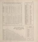
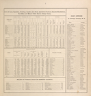
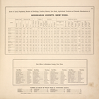
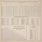
Acres of Land, Population, Dw…
Acres of Land, Population, Dw…
Acres of Land, Population, Dw…
Acres of Land, Population, Dw…
Acres of Land, Population, Dw…
Acres of Land, Valuation, Pop…
Acres of Land, Valuation, Pop…
1
2
3
4
5
6
7
8
9
10
…
21
22
Previous
Next
1
2
3
4
5
6
7
8
9
10
…
21
22
Previous
Next