Click to visit the main New York Public Library Homepage
The New York Public Library
Digital Collections
About Digital Collections
Browse
Search only public domain materials
Items
Collections
Divisions
Home
Search
Browse
About
Search only public domain materials
Items
Collections
Divisions
Digital Collections
Using Images
Using Data
Search
Filtered search
Show filters
Hide filters
Show Only Public Domain
topic
Landowners
9
Real property
9
Cities and towns
4
Buildings
3
Nautical charts
3
More
Less
name
H.F. Walling's Map Establishment
3
United States Coast Survey
3
Walling, Henry Francis, 1825-1888
3
Alden, James, 1810-1877
2
Bache, A. D. (Alexander Dallas), 1806-1867
2
More
Less
collection
Maps of North America
14
The Holy Land, Syria, Idumea, Arabia, Egypt and Nubia: From drawings made on the spot
2
American slavery and colour
1
Egypt & Nubia
1
Lawrence H. Slaughter Collection of English maps, charts, globes, books and atlases
1
More
Less
place
Ohio
5
Maine
3
California
2
Middle East
2
Pacific Coast
2
More
Less
genre
x
Illustrations
Maps
17
Cadastral maps
8
Prints
5
Nautical charts
2
More
Less
publisher
F.G. Moon,
2
Lee & Marsh
2
U.S. Coast Survey
2
publisher not identified
2
Arthus Bertrand
1
More
Less
division
Map Division
15
General Research Division
4
Dorot Jewish Division
2
Schomburg Manuscripts, Archives and Rare Books Division
1
type
x
cartographic
still image
15
text
1
Date Range
to
22 results found
Filtering on:
x
Date
: 1844 - 1861
x
Genre
: Illustrations
x
Type
: cartographic
Sort by:
Title
Date created
Date digitized
Sequence
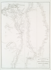
Turkey III: containing the So…
m
Atlas géologique
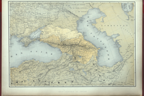
Carte generale du Caucase.
Map of free states, slave sta…
m
Topographical map of the coun…
m
City of Toledo, Lucas Co., Oh…
Reconnaissance of the western…
Map of Clinton County, Ohio
Reconnaissance of the western…
m
Map of Columbiana County, Ohi…
m
Map of Trumbull County, Ohio
Map of Perry County, Ohio
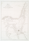
Reconnaissance of the S.E. en…
Map of the city of Davenport …
Octagonal map of the environs…
Leavitt's map with views of t…
Map of Waldo County, Maine: f…
m
A topographical map of Lincol…
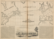
Map of the Submarine Atlantic…
Map to illustrate the sketche…
Map to Illustrate the Route o…
Map to illustrate the sketche…
End of results
|
Top