Click to visit the main New York Public Library Homepage
The New York Public Library
Digital Collections
About Digital Collections
Browse
Search only public domain materials
Items
Collections
Divisions
Home
Search
Browse
About
Search only public domain materials
Items
Collections
Divisions
Digital Collections
Using Images
Using Data
Search
Filtered search
Show filters
Hide filters
Show Only Public Domain
topic
x
Railroads
Canals
7
Administrative and political divisions
3
Coal mines and mining
1
Counties
1
More
Less
name
Tanner, Henry Schenck, 1786-1858
4
Mitchell, S. Augustus (Samuel Augustus), 1792-1868
2
Sherman & Smith
2
Atwood, John M., approximately 1818-
1
Bonner, William G
1
More
Less
collection
Maps of North America
13
Maps of New York City and State
4
place
Massachusetts
5
New York (State)
4
New Jersey
3
United States
3
Boston
2
More
Less
genre
Maps
17
publisher
publisher not identified
3
H.S. Tanner
2
S. Augustus Mitchell
2
C. Dinsmore, Publisher, No. 2 Spruce Strt
1
D. Appleton & Co
1
More
Less
division
Map Division
17
type
x
cartographic
Date Range
to
17 results found
Filtering on:
x
Date
: 1845 - 1848
x
Topic
: Railroads
x
Type
: cartographic
Sort by:
Title
Date created
Date digitized
Sequence
Map of the state of Georgia :…
Map of the canals and rail ro…
Massachusetts and Rhode Island
Plan showing the proposed ent…
Extract from Borden's map of …
m
Map of Essex & part of Middle…
Map of Massachusetts, Connect…
Sketch of the states of Massa…
Map of the country thirty thr…
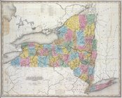
Map of the state of New York …
New York
m
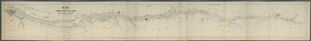
Map of the Hudson River Rail …
Skeleton map showing the rail…
A map of the canals & rail ro…
A map of the canals & rail ro…
Map of the eastern and middle…
Complete railway map designed…
End of results
|
Top