Click to visit the main New York Public Library Homepage
The New York Public Library
Digital Collections
About Digital Collections
Browse
Search only public domain materials
Items
Collections
Divisions
Home
Search
Browse
About
Search only public domain materials
Items
Collections
Divisions
Digital Collections
Using Images
Using Data
Search
Filtered search
Show filters
Hide filters
Show Only Public Domain
topic
Real property
102
Landowners
82
Administrative and political divisions
22
Cities and towns
15
Villages
10
More
Less
name
Walling, Henry Francis, 1825-1888
19
Smith, Robert Pearsall, 1827-1898
17
H.F. Walling's Map Establishment
9
French, J. H. (John Homer), 1824-1888
6
Rease, W. H
5
More
Less
collection
Maps of New York City and State
62
Maps of North America
50
place
New York (State)
61
Massachusetts
15
New York
7
Wisconsin
5
Illinois
4
More
Less
genre
x
Cadastral maps
Maps
112
Illustrations
7
Pictorial works
5
Bathymetric maps
2
More
Less
publisher
publisher not identified
22
J.H. French
4
Lee & Marsh
3
E.A. Balch
2
H.F. Walling
2
More
Less
division
Map Division
112
type
x
cartographic
still image
12
Date Range
to
112 results found
Filtering on:
x
Date
: 1849 - 1859
x
Genre
: Cadastral maps
x
Type
: cartographic
Sort by:
Title
Date created
Date digitized
Sequence
m
Peremptory sale of a suburban…
Flushing
m
Map of the southern part of W…
m
Map of Ulster County, New York
m
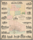
Map of Washington County, New…
Subdivision of Block 5 of the…
m
Topographical map of the coun…
m
Map of Rockingham Co., New Ha…
m
Norman's plan of New Orleans …
Map of the mouth of St. Clair…
Map of the city of Saint Paul…
Map of the town of Huron, Mic…
Topographical map of lands be…
Map of the city of Milwaukee,…
m
City of Toledo, Lucas Co., Oh…
Map of Chicago and vicinity
Superior, Douglass County, Wi…
Harbor of Manitowoc, Wis. : t…
Harbor of Manitowoc, Wis. : t…
m
Map of Dutchess Co., New York…
m
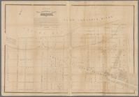
Map of Kings and part of Quee…
m
Map of Albany County, New Yor…
m
This plan of the city of Balt…
Map of Clinton County, Ohio
m
Map of Trumbull County, Ohio
Map of Perry County, Ohio
Official map of the city of S…
Map of lands belonging to Jam…
Map of the town of Blackstone…
Map of the town of Fairhaven,…
A plan of the land belonging …
Map of the city of Davenport …
m
Superior, Douglas County, Wis…
Map of the State of Georgia
m
Map of the city of Williamsbu…
m
Map of Vigo County, Indiana
m
Topographical map of the Coun…
Map of the town of Raynham, B…
Map of Venango County, Pennsy…
City of Covington
Map of Northumberland County,…
m
Map of the city of Newark, N.…
A new map of the city of Buff…
A plan of the Manor of Philip…
Map of the town of Waterloo, …
Town & village of Seneca Fall…
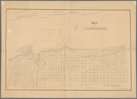
Map of Ogdensburgh
Plan of the easterly part of …
Town of Greenburgh: Westchest…
Atherton, St. Lawrence County…