Click to visit the main New York Public Library Homepage
The New York Public Library
Digital Collections
About Digital Collections
Browse
Search only public domain materials
Items
Collections
Divisions
Home
Search
Browse
About
Search only public domain materials
Items
Collections
Divisions
Digital Collections
Using Images
Using Data
Search
Filtered search
Show filters
Hide filters
Show Only Public Domain
topic
Nautical charts
32
Harbors
10
Coasts
6
Ocean currents
2
Pilot guides
2
More
Less
name
United States Coast Survey
28
Bache, A. D. (Alexander Dallas), 1806-1867
22
Knight, C. A
10
Alden, James, 1810-1877
9
P.S. Duval & Co
7
More
Less
collection
Maps of North America
30
Explanations and sailing directions to accompany the Wind and current charts,
2
Maps of New York City and State
2
place
Massachusetts
6
Washington (State)
5
Atlantic Ocean
4
California
4
Florida
3
More
Less
genre
x
Nautical charts
Maps
32
Bathymetric maps
12
Pictorial works
1
Prints
1
publisher
U.S. Coast Survey
17
U.S. Coast Survey Office
6
United States Coast Survey
3
E.C. and J. Biddle
2
U. S. Coast Survey Office
2
More
Less
division
Map Division
32
General Research Division
2
type
cartographic
34
still image
1
Date Range
to
34 results found
Filtering on:
x
Date
: 1854 - 1854
x
Genre
: Nautical charts
Sort by:
Title
Date created
Date digitized
Sequence
Reconnaissance of Pass Fourch…
Reconnaissance of Grenville H…
Reconnaissance of Duwamish Ba…
Reconnaissance of Canal de Ha…
Preliminary surveys of harbor…
Map of comparison of Maffitt'…
Entrance to Columbia River, O…
Preliminary survey of the ent…
Reconnaissance of Port Townsh…
Reconnaissance of Smith's or …
Preliminary chart of Ship and…
Preliminary chart of Nantucke…
Preliminary chart of Cedar Ke…
Preliminary survey of Turtle …
Reconnaissance of Coffin's Pa…
Preliminary survey of Winyah …
Preliminary chart of Plymouth…
Preliminary chart of Beaufort…
Preliminary chart of the sea …
Preliminary survey of harbors…
Map of Buffalo Harbor, N.Y., …
Preliminary chart of Stellwag…
York River and Cape Neddick h…
Reconnaissance of the eastern…
Preliminary chart of Portland…
Preliminary chart of Portsmou…
Map of parts of Boston Harbor…
Preliminary chart of Muskeget…
Preliminary chart of Bass Riv…
Reconnaissance of the western…
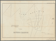
Oswego Harbor, 33d Congress, …
Approximate cotidal lines of …
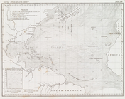
Gulf Stream and Drift
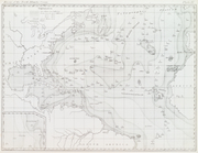
Basin of the North Atlantic O…
End of results
|
Top