Click to visit the main New York Public Library Homepage
The New York Public Library
Digital Collections
About Digital Collections
Browse
Search only public domain materials
Items
Collections
Divisions
Home
Search
Browse
About
Search only public domain materials
Items
Collections
Divisions
Digital Collections
Using Images
Using Data
Search
Filtered search
Show filters
Hide filters
Show Only Public Domain
topic
x
Real property
Cities & towns
3188
Fire insurance
3188
Business enterprises
468
Landowners
246
More
Less
name
Sanborn Map Company
3188
Beers, F. W. (Frederick W.)
356
E. Robinson Co
256
Robinson, E. (Elisha)
248
Pidgeon, R. H. (Roger H.)
223
More
Less
collection
Atlases of New York City
3841
Atlases of the United States
1293
Maps of North America
237
Maps of New York City and State
151
place
New York (State)
5136
New York
646
Brooklyn (New York, N.Y.)
244
Manhattan (New York, N.Y.)
212
New York (N.Y.)
150
More
Less
genre
Maps
5332
Atlases
1290
Cadastral maps
286
Prints
69
Title pages
37
More
Less
publisher
Sanborn Map Company
3188
E. Robinson Co
209
F. W. Beers & Co
148
Perris & Browne
124
G.M. Hopkins & Co
108
More
Less
division
Map Division
5392
type
cartographic
5400
text
141
still image
24
Date Range
to
5,522 results found
Filtering on:
x
Date
: 1855 - 1891
x
Topic
: Real property
Sort by:
Title
Date created
Date digitized
Sequence
1st & 2nd Wards. [Map bounded…
1st & 3rd Wards. [Map bounded…
1st Ward. [Map bounded by Bow…
1st Ward. [Map bounded by Exc…
1st Ward. [Map bounded by Lib…
1st Ward. [Map bounded by Sto…
1st Ward. [Map bounded by Wes…
2nd & 4th Wards. [Map bounded…
2nd Ward. [Map bounded by Bro…
2nd Ward. [Map bounded by Pea…
2nd Ward. [Map bounded by Wil…
3rd Ward. [Map bounded by Col…
3rd Ward. [Map bounded by Ful…
3rd Ward. [Map bounded by Gre…
3rd Ward. [Map bounded by Rob…
3rd Ward. [Map bounded by Wes…
4th Ward. [Map bounded by Cat…
4th Ward. [Map bounded by Gol…
4th Ward. [Map bounded by Pec…
4th Ward. [Map bounded by Roo…
4th Ward.[Map bounded by Oak …
A compleat map of North-Carol…
A map of part of the land in …
A map of St. Augustine & vici…
A map of the original allotme…
A map of the original allotme…
A map of the town of New-ark …
A new map of the city of Buff…
A new sectional map of Florid…
A plan of the land belonging …
A plan of the town of Pittsfo…
A plott of ye situations of t…
A topographical map of Lewis …
m
A topographical map of Lincol…
m
A topographical map of Lincol…
A topographical map of Steube…
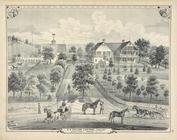
A. C. Osborn. ; Res. of A. C.…
A. H. Taylor's Central Valley…
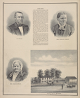
A. T. Miner. ; Mrs. Caroline …
m
Abbott's map of the city of M…
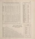
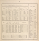
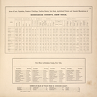
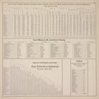
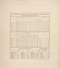
Acres of Land, Population, Dw…
Acres of Land, Population, Dw…
Acres of Land, Population, Dw…
Acres of Land, Population, Dw…
Acres of Land, Population, Dw…
Acres of Land, Valuation, Pop…
Acres of Land, Valuation, Pop…
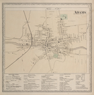
Adams [Village]; Adams Busine…
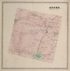
Adams. [Township]
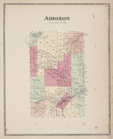
Addison [Township]
1
2
3
4
5
6
7
8
9
10
…
22
23
Previous
Next
1
2
3
4
5
6
7
8
9
10
…
22
23
Previous
Next