Click to visit the main New York Public Library Homepage
The New York Public Library
Digital Collections
About Digital Collections
Browse
Search only public domain materials
Items
Collections
Divisions
Home
Search
Browse
About
Search only public domain materials
Items
Collections
Divisions
Digital Collections
Using Images
Using Data
Search
Filtered search
Show filters
Hide filters
Show Only Public Domain
topic
Real property
13
History
12
Landowners
12
Railroads
10
Administrative and political divisions
7
More
Less
name
Hayward, George, approximately 1800-
3
P.S. Duval & Son
3
Valentine, D. T. (David Thomas), 1801-1869
3
Boston (Mass.). Engineering Department
2
Daniels, John H., 1828-1901
2
More
Less
collection
Maps of North America
50
Maps of New York City and State
15
place
New York (State)
12
Pennsylvania
8
United States
8
Virginia
8
Massachusetts
7
More
Less
genre
Maps
65
Cadastral maps
9
Geological maps
4
Illustrations
2
Manuscript maps
2
More
Less
publisher
x
publisher not identified
D. McLellan, lithographer
1
Lith of R.H. Pease
1
division
Map Division
65
type
x
cartographic
still image
3
text
2
Date Range
to
65 results found
Filtering on:
x
Date
: 1856 - 1864
x
Publisher
: publisher not identified
x
Type
: cartographic
Sort by:
Title
Date created
Date digitized
Sequence
Plan of Public Garden: showin…
Skeleton map of the overland …
Plan of extension of Devonshi…
Plan of extension of Devonshi…
Chengwatana, Pine County, M.T…
A plan of the operations of t…
Map of the town of Huron, Mic…
Map of the tertiary of Essex …
Superior, Douglass County, Wi…
Map of the state of Californi…
Geological reconnaissances in…
Map of the canals and rail ro…
m
The Wyoming Coal Field and it…
Plan of the seat of war : [Vi…
Yosemite Valley : [Calif.]
Plan of Gettysburg with the b…
m
Topographical map of the Wyom…
Geological and sectional map …
Sketch showing route of gener…
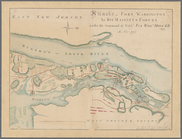
Attacks of Fort Washington by…
Map of the Clinton County Coa…
Map of part of Fauquier Count…
m
Military map of Nebraska and …
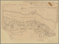
Attacks of Fort Washington by…
Map of the city of Davenport …
A compleat map of North-Carol…
Charleston : a map showing th…
Plat of the town of Elmhurst,…
A map of the state of Virgini…
Map of routes & distances to …
Position of Richmond, Va. : p…
Octagonal map of the environs…
Approach of the Union Armies …
Map of Venango County, Pennsy…
Map of the oil region, Venang…
Brattleboro and vicinity : co…
A map of part of the land in …
Plan of the New Haven City bu…
General map accompanying the …
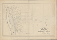
Map of the water pipes in the…
Atherton, St. Lawrence County…
Massachusetts, Connecticut an…
Part of New Jersey : embracin…
Plan of the cemetery of Mount…
Map of Castle Hill & Price's …
Plan of Boston: corrected und…
Plan of Boston: prepared unde…
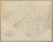
Map of Orange County: [New Yo…
Map of part of Orange County,…
Map of New York, New England,…