Click to visit the main New York Public Library Homepage
The New York Public Library
Digital Collections
About Digital Collections
Browse
Search only public domain materials
Items
Collections
Divisions
Home
Search
Browse
About
Search only public domain materials
Items
Collections
Divisions
Digital Collections
Using Images
Using Data
Search
Filtered search
Show filters
Hide filters
Show Only Public Domain
topic
x
Real property
Fire insurance
5093
Cities & towns
5007
Business enterprises
468
Landowners
257
More
Less
name
Sanborn Map Company
5103
G.W. Bromley & Co
1883
Ullitz, Hugo
606
E.B. Hyde & Co
545
E. Belcher Hyde Map Company
488
More
Less
collection
Atlases of New York City
8037
Atlases of the United States
1795
Maps of North America
259
Maps of New York City and State
186
Photographic views of New York City, 1870's-1970's, from the collections of the New York Public Library
23
More
Less
place
New York (State)
9779
New York
2908
Manhattan (New York, N.Y.)
1568
Brooklyn (New York, N.Y.)
793
New York (N.Y.)
455
More
Less
genre
Maps
9983
Atlases
1792
Cadastral maps
398
Indexes
122
Title pages
71
More
Less
publisher
Sanborn Map Company
5009
G.W. Bromley & Co
1703
E. Belcher Hyde
425
E. Robinson Co
246
F. W. Beers & Co
148
More
Less
division
Map Division
10120
Milstein Division
52
Manuscripts and Archives Division
18
Schomburg Jean Blackwell Hutson Research and Reference Division
10
type
cartographic
10052
text
327
still image
74
Date Range
to
10,330 results found
Filtering on:
x
Date
: 1856 - 1938
x
Topic
: Real property
Sort by:
Title
Date created
Date digitized
Sequence
m
#4148-1 From Market & Hamilto…
m
#4321-5 Market and Cherry Sts…
m
146 Cherry Street in the "Lun…
m
4044-1 Cherry St. lkg. West f…
m
4044-2 Market St. lkg. North …
m
4044-6 Lkg. South on Catherin…
m
4044-7 Lkg. West on Monroe St…
m
4044-8 Lkg. South on Market S…
A compleat map of North-Carol…
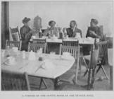
A corner of the dining room i…
A map of part of the land in …
A map of St. Augustine & vici…
A map of the original allotme…
A map of the town of New-ark …
A new sectional map of Florid…
A new sectional map of Florid…
A plan of the town of Pittsfo…
A plott of ye situations of t…
A topographical map of Lewis …
m
A topographical map of Lincol…
m
A topographical map of Lincol…
A topographical map of Steube…
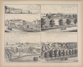
A. C. Osborn. ; Res. of A. C.…
A. H. Taylor's Central Valley…
A. T. Miner. ; Mrs. Caroline …
m
Abbott's map of the city of M…
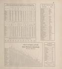
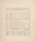
Acres of Land, Population, Dw…
Acres of Land, Population, Dw…
Acres of Land, Population, Dw…
Acres of Land, Population, Dw…
Acres of Land, Population, Dw…
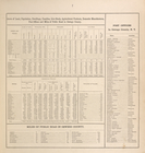
Acres of Land, Valuation, Pop…
Acres of Land, Valuation, Pop…
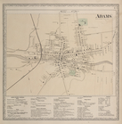
Adams [Village]; Adams Busine…
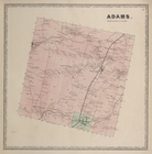
Adams. [Township]
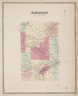
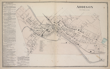
Addison [Township]
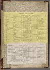
Addison Business Notices; Add…
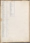
Additional Index
Additional Index
Additional Index
Additional Index
Additional Index
Additional Index
akeside" Res. of the Family o…
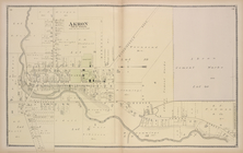
Akron [Village]
Akron [Village]; Newstead [To…
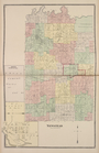
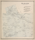
Albion [Township]; New Center…
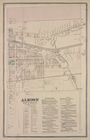
Albion East of Main St. [Vill…
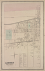
Albion West of Main St.
Alden [Township]
1
2
3
4
5
6
7
8
9
10
…
41
42
Previous
Next
1
2
3
4
5
6
7
8
9
10
…
41
42
Previous
Next