Click to visit the main New York Public Library Homepage
The New York Public Library
Digital Collections
About Digital Collections
Browse
Search only public domain materials
Items
Collections
Divisions
Home
Search
Browse
About
Search only public domain materials
Items
Collections
Divisions
Digital Collections
Using Images
Using Data
Search
Filtered search
Show filters
Hide filters
Show Only Public Domain
topic
Real property
5
Landowners
3
Cities and towns
2
Railroads
2
Administrative and political divisions
1
More
Less
name
Rease, W. H
2
Beers, S. N
1
Bingham, Reuben H
1
Chambers, Frederick C., surveyor
1
Clark, Benjamin A
1
More
Less
collection
Maps of New York City and State
5
place
x
New York (State)
Bath (N.Y.)
2
Addison
1
Addison (N.Y.)
1
Albany
1
More
Less
genre
x
Cadastral maps
Maps
5
Topographic maps
1
publisher
Benj. A. Clark
1
Herline & Hensel
1
J.E. Gillette, Publisher
1
J.H. French
1
S. & R.S. Taintor Jr. & Co., Publishs
1
More
Less
division
Map Division
5
type
x
cartographic
Date Range
to
5 results found
Filtering on:
x
Date
: 1857 - 1857
x
Genre
: Cadastral maps
x
Place
: New York (State)
x
Type
: cartographic
Sort by:
Title
Date created
Date digitized
Sequence
Town of Greenburgh: Westchest…
m
Map of the city of Albany: wi…
m
Schuyler County, New York, wi…
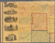
A topographical map of Steube…
A topographical map of Lewis …