Click to visit the main New York Public Library Homepage
The New York Public Library
Digital Collections
About Digital Collections
Browse
Search only public domain materials
Items
Collections
Divisions
Home
Search
Browse
About
Search only public domain materials
Items
Collections
Divisions
Digital Collections
Using Images
Using Data
Search
Filtered search
Show filters
Hide filters
Show Only Public Domain
topic
x
Administrative and political divisions
Real property
4
Landowners
3
Buildings
2
Census
1
More
Less
name
Hopkins, Griffith Morgan, Jr
2
Lee & Marsh
2
Smith, Robert Pearsall, 1827-1898
2
Bingham, Reuben H
1
Chace, J
1
More
Less
collection
Maps of North America
7
Maps of New York City and State
3
place
Boston (Mass.)
2
Lincoln County
2
Lincoln County (Me.)
2
Maine
2
New York (State)
2
More
Less
genre
Maps
10
Cadastral maps
4
Illustrations
1
Pictorial works
1
publisher
Lee & Marsh
2
B.M. Norman
1
George G. Smith
1
J.H. Colton & Co
1
Published by Keen & Lee
1
More
Less
division
Map Division
10
type
x
cartographic
still image
2
Date Range
to
10 results found
Filtering on:
x
Date
: 1857 - 1857
x
Topic
: Administrative and political divisions
x
Type
: cartographic
Sort by:
Title
Date created
Date digitized
Sequence
m
Map of Rockingham Co., New Ha…
m
Norman's plan of New Orleans …
m
A sectional map of Iowa
m
A topographical map of Lincol…
Plan of Boston comprising a p…
m
A topographical map of Lincol…
m
Map of the city of Albany: wi…
Census of the State of New Yo…
m
Mitchell's new national map e…
m
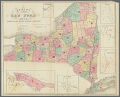
City & county map of New York…