Click to visit the main New York Public Library Homepage
The New York Public Library
Digital Collections
About Digital Collections
Browse
Search only public domain materials
Items
Collections
Divisions
Home
Search
Browse
About
Search only public domain materials
Items
Collections
Divisions
Digital Collections
Using Images
Using Data
Search
Filtered search
Show filters
Hide filters
Show Only Public Domain
topic
Description and travel
1
Enslaved persons
1
name
Royal Geographical Society (Great Britain)
2
Swanston, George H
2
A. Fullarton & Co
1
Cartography Associates
1
Johnston, Alexander Keith, 1804-1871
1
More
Less
collection
A map showing the routes of some native caravans from the coast to the interior of Eastern Africa, from information collected by the Rev. T. Wakefield ... also of two personal journeys to the Southern Galla country made by the Rev. Wakefield & C. New in 1865 and 1866-7
1
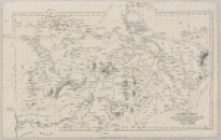
Countries in the northern tropical regions of Africa
1
Map of part of Central Africa: according to Clapperton, Denham, Richardson, Barth, Vogel & Baikie from original documents in possession of the Royal Geographical Society of London
1
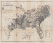
Map showing the distribution of slaves in the Southern States
1
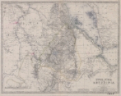
Upper Nubia and Abyssinia
1
More
Less
place
Africa, Central
1
Africa, Eastern
1
Ethiopia
1
Maps
1
Senegal
1
More
Less
genre
Maps
5
Prints
1
publisher
A. Fullarton & Co
1
A. von Steinwehr
1
Hachette
1
Published for the Royal Geographical Society by J. Murray
1
W. Blackwood & Sons
1
division
x
Schomburg Jean Blackwell Hutson Research and Reference Division
type
x
cartographic
Date Range
to
6 results found
Filtering on:
x
Date
: 1866 - 1872
x
Division
: Schomburg Jean Blackwell Hutson Research and Reference Division
x
Type
: cartographic
Sort by:
Title
Date created
Date digitized
Sequence
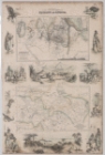
Carte du Soudan Occidental dr…
Countries in the northern tro…
Map showing the distribution …
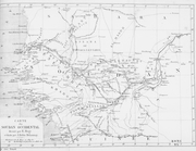
A map showing the routes of s…
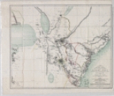
Map of part of Central Africa…
Upper Nubia and Abyssinia