Click to visit the main New York Public Library Homepage
The New York Public Library
Digital Collections
About Digital Collections
Browse
Search only public domain materials
Items
Collections
Divisions
Home
Search
Browse
About
Search only public domain materials
Items
Collections
Divisions
Digital Collections
Using Images
Using Data
Search
Filtered search
Show filters
Hide filters
Show Only Public Domain
topic
Real property
57
Administrative and political divisions
15
Landowners
15
Mines and mineral resources
9
Railroads
8
More
Less
name
J.B. Beers & Co
51
G.M. Hopkins & Co
31
Bevan, John
6
Sanford, Everts & Co
6
Bechler, Gustavus R
3
More
Less
collection
Atlases of the United States
82
Maps of North America
46
Maps of New York City and State
21
Countries in the northern tropical regions of Africa
1
Map of part of Central Africa: according to Clapperton, Denham, Richardson, Barth, Vogel & Baikie from original documents in possession of the Royal Geographical Society of London
1
More
Less
place
New York (State)
63
Westchester County
46
Westchester County (N.Y.)
46
Buffalo (N.Y.)
31
Massachusetts
7
More
Less
genre
x
Maps
Atlases
51
Cadastral maps
9
Geological maps
3
Bathymetric maps
2
More
Less
publisher
G.M. Hopkins
31
J.B. Beers & Co
7
Bevan, John
6
Sanford, Everts & Co
6
Geological Survey of Indiana
3
More
Less
division
Map Division
149
Schomburg Jean Blackwell Hutson Research and Reference Division
2
General Research Division
1
Milstein Division
1
Wallach Division: Picture Collection
1
type
cartographic
152
still image
3
text
2
Date Range
to
154 results found
Filtering on:
x
Date
: 1872 - 1872
x
Genre
: Maps
Sort by:
Title
Date created
Date digitized
Sequence
m
Bridgman's map of the suburbs…
m
Watson's new map of New York,…
Map of the rail roads of the …
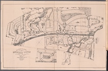
The Suburban Town of Ridley P…
New and enlarged map of Balti…
Bird's eye view of Philadelph…
Map of part of Marquette Coun…
m
Map of the city of St. Louis,…
Township no. 20 North, Range …
Map of Philadelphia photograp…
Map of the Iron Cliffs Co.'s …
Map showing lands of the Iron…
Map showing iron mines in vic…
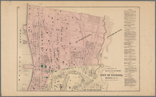
New and improved map of the c…
Map of the iron mines of Lake…
Map of Dearborn, Ohio, and Sw…
Map of Pike and Dubois Counti…
Map of roads from Fort Dodge,…
Guide map of the best and sho…
North western America : showi…
Map of the sources of Snake R…
County map of the state of Ca…
Map showing the economic mine…
Map of military department of…
Railroad map of Iowa
Map of the Lower Geyser Basin…
Map of the Upper Geyser Basin…
m
Map and geological cross-sect…
Map of Parke County, Indiana
Map of Cook and DuPage Counti…
m
Topographical map of Hunterdo…
A plan of the town of Pittsfo…
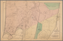
Southern part of Yonkers, and…
Narraganset Bay: [Rhode Islan…
m
New national map of the Unite…
Portions of 2nd, 3rd, and 4th…
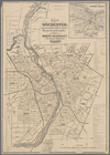
Map of Rochester: from the la…
Portions of 1st, 2nd, and 3rd…
Map of Oregon, Washington, Id…
Limington: [Maine]
m
Map of Boston, 1872: after th…
Map of Boston: from the lates…
Hollis: [Maine]
Lebanon: [Maine]
Spring Vale
North Berwick: [Maine]
North Berwick: [Maine]. Limin…
Edgartown harbor and Cotamy B…
Explorations and surveys sout…
Map of Boston: from the lates…