Click to visit the main New York Public Library Homepage
The New York Public Library
Digital Collections
About Digital Collections
Browse
Search only public domain materials
Items
Collections
Divisions
Home
Search
Browse
About
Search only public domain materials
Items
Collections
Divisions
Digital Collections
Using Images
Using Data
Search
Filtered search
Show filters
Hide filters
Show Only Public Domain
topic
Real property
36
Business enterprises
31
Administrative and political divisions
17
Railroads
9
Indian reservations
5
More
Less
name
J.B. Beers & Co
49
Beers, F. W. (Frederick W.)
35
D.G. Beers & Co
31
Nichols, Beach
21
Pomeroy, Whitman & Co
21
More
Less
collection
Atlases of the United States
52
Atlases of New York City
49
Maps of North America
37
Maps of New York City and State
23
Voyage d'exploration a la mer Morte, a Petra, et sur la rive gauche du Jourdain
2
More
Less
place
New York (State)
75
Staten Island (New York, N.Y.)
35
Wayne County
31
Wayne County (N.Y.)
31
Schuyler County
20
More
Less
genre
Maps
164
Atlases
52
Cadastral maps
3
Geological maps
3
Nautical charts
3
More
Less
publisher
J.B. Beers & Co
36
J.H. Toudy & Co
31
Pomeroy, Whitman & Co
21
Adirondack survey
4
Corps of Engineers
3
More
Less
division
Map Division
163
Dorot Jewish Division
2
Wallach Division: Print Collection
1
type
x
cartographic
text
3
still image
1
Date Range
to
166 results found
Filtering on:
x
Date
: 1874 - 1874
x
Type
: cartographic
Sort by:
Title
Date created
Date digitized
Sequence
Map of Boston and the country…
Carte pittoresque des environ…
A.R. Roessler's latest map of…
A geological map of the Black…
Map of the Black Hills : from…
m
Post route map of the states …
Campaign map of the Departmen…
Campaign map of the Departmen…
Campaign map of the Departmen…
Map of Massachusetts: to acco…
Pittsburgh & Western Pennsylv…
Johnson's Nebraska, Dakota, I…
Geological map of western Wyo…
Map of the Military Departmen…
Preliminary post route map of…
Plan of the French and Americ…
Map of the city of Worcester
Map of parts of Montana, Idah…
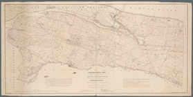
Map of Long Island: showing t…
Kentucky et Tennessee
New Orleans : map of the revo…
Adirondack survey, 1873: prim…
m
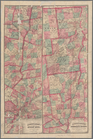
Colton's New Jersey
m
Guide map of the city of Eliz…
A plan of New Haven and harbo…
Plan of cemetery of the Everg…
Asher & Adams' United States …
m
Northern New Jersey, showing …
Map of Taunton: [Massachusett…
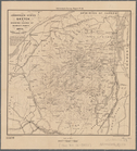
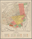
Map of northern boundary line…
m
Post route map of the states …
Map of Boston for 1874: publi…
m
Map of the states of Kansas a…
Reconnaissance of the western…
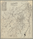
Ancient Windham County: names…
Russell's map of Massachusetts
m
Map showing the limits of the…
m
Map showing the lines of the …
Topographical map made from s…
Carta particolare della nuoua…
Map of the New York wildernes…
Adirondack survey, 1873: Bald…
Asher & Adams' new map of the…
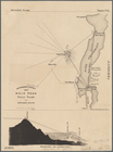
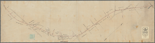
Plan showing route of Rochest…
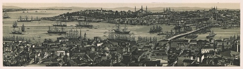
Constantinople, 1874.
Adirondack survey, sketch sho…
Adirondack survey, Sketch in …
Map showing, in five degrees …
Asher & Adams' map of the bay…
m
United States--east coast, Ne…