Click to visit the main New York Public Library Homepage
The New York Public Library
Digital Collections
About Digital Collections
Browse
Search only public domain materials
Items
Collections
Divisions
Home
Search
Browse
About
Search only public domain materials
Items
Collections
Divisions
Digital Collections
Using Images
Using Data
Search
Filtered search
Show filters
Hide filters
Show Only Public Domain
topic
x
Landowners
Real property
57
Administrative and political divisions
18
History
3
Historical geography
2
More
Less
name
Worley & Bracher
18
Warner & Foote
15
Bourquin, F. (Frederick), 1808-
11
Beers, D. G. (Daniel G.)
9
H.J. Toudy & Co
9
More
Less
collection
Maps of North America
51
Maps of New York City and State
22
place
New York (State)
22
Minnesota
10
Virginia
8
Kentucky
7
Massachusetts
5
More
Less
genre
Maps
73
Cadastral maps
49
Wall maps
3
Facsimiles
1
Illustrations
1
More
Less
publisher
Published by Warner & Foote
9
publisher not identified
7
D.G. Beers & Co
6
Published by authority of the Hon. the Secretary of War, Office of the Chief of Engineers, U.S. Army
6
Warner & Foote
6
More
Less
division
Map Division
73
type
cartographic
73
still image
1
Date Range
to
73 results found
Filtering on:
x
Date
: 1875 - 1880
x
Topic
: Landowners
Sort by:
Title
Date created
Date digitized
Sequence
Map of Conanicut Island, oppo…
Plan of real estate at Harris…
m
Map of Bates County, Missouri
m
Map of Johnson County, Missou…
m
Map of Pettis County, Missour…
m
Map of Goodhue County, Minnes…
m
Map of Stearns County, Minnes…
m
Map of Hennepin County, Minne…
m
Map of Meeker County, Minneso…
m
Map of McLeod County, Minneso…
m
Map of Christian County, Ky. …
Plan of the Brunswick lots in…
Plan of the city of New Orlea…
Map of a portion of Point Ke…
m
Map of Scott County, Minnesot…
m
Map of LeSueur County, Minnes…
Map of Rochester, Olmsted Co.…
Map of Lake Minnetonka : show…
m
Abbott's map of the city of M…
m
Map of Monroe County, Wiscons…
Map of part of the Manor of P…
Map of the town of Eastcheste…
m
Map of Maury Co., Tennessee :…
m
Map of Haywood County, Tenn. …
Map of Shenandoah & Page coun…
Map of Rockingham County, Vir…
m
Map number sixteen : [Berkele…
m
Map of Henry County, Missouri
m
Map of Cass County, Missouri
Map of Augusta County, Virgin…
Map of Rappahannock County, V…
Map of Greene County, Virgini…
m
Map of Elizabeth City Co., Va…
Map of Madison County, Virgin…
Plan of the town Ebenezer and…
m
Map of Charlotte, Mecklenberg…
m
Map of Marion and Washington …
m
Map of Madison County, Tenn. …
The Caron map of the city of …
Gray's new map of Hampton, El…
m
Map of Harrison County, Ky. :…
m
Map of Garrard and Lincoln co…
m
Map of Montgomery County, Ken…
m
Map of Scott Co., Kentucky : …
County and railroad map of th…
Official map of the city of J…
Llewellyn Park, West Orange, …
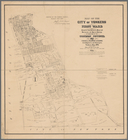
Map of the city of Yonkers, F…
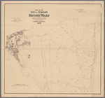
Map of the city of Yonkers, S…
Map of the flats above Albany