Click to visit the main New York Public Library Homepage
The New York Public Library
Digital Collections
About Digital Collections
Browse
Search only public domain materials
Items
Collections
Divisions
Home
Search
Browse
About
Search only public domain materials
Items
Collections
Divisions
Digital Collections
Using Images
Using Data
Search
Filtered search
Show filters
Hide filters
Show Only Public Domain
topic
Pictorial works
39
Landowners
12
Railroads
11
Real property
11
Administrative and political divisions
10
More
Less
name
E.B. Hyde & Co
39
Worley & Bracher
10
H.J. Toudy & Co
7
Geological Survey of Pennsylvania
6
Hart, Lane S
6
More
Less
collection
Maps of North America
41
Atlases of the United States
40
Maps of New York City and State
12
Spezialkarte der Osterreichisch-Ungarischen Monarchie
1
The languages and races of Dardistan
1
place
Passaic County (N.J.)
39
New York (State)
9
Pennsylvania
6
Missouri
4
New York (N.Y.)
4
More
Less
genre
Maps
95
Atlases
39
Cadastral maps
10
Geological maps
8
Topographic maps
4
More
Less
publisher
D.G. Beers & Co
4
Department of the Interior, U.S. Geological and Geographical Survey of the Territories
4
Second Geological Survey of Pennsylvania
4
Warner & Foote
4
Geological Survey of New Jersey
2
More
Less
division
Map Division
94
Rare Book Division
1
type
x
cartographic
text
2
still image
1
Date Range
to
95 results found
Filtering on:
x
Date
: 1877 - 1877
x
Type
: cartographic
Sort by:
Title
Date created
Date digitized
Sequence
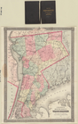
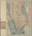
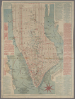
Map of New York City, south o…
New map of Brooklyn and vicin…
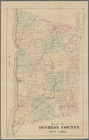
Water shed of the Passaic Riv…
m
Map of Bates County, Missouri
m
Map of Johnson County, Missou…
m
Map of Goodhue County, Minnes…
Railroads of Minneapolis and …
m
Map of Monroe County, Wiscons…
Economic map of Colorado
General geological map of Col…
Drainage map of Colorado
Map of the city of Nashville …
Map of Rockingham County, Vir…
m
Map of Haywood County, Tenn. …
m
Map of Arizona : prepared spe…
Bancroft's official guide map…
m
Map of Henry County, Missouri
m
Map of Cass County, Missouri
Map of Indiana
m
Map of Charlotte, Mecklenberg…
m
Map of Marion and Washington …
m
Map of Madison County, Tenn. …
m
Map of Harrison County, Ky. :…
Map of Beaver County showing …
Map of southern Butler County…
Geological map of Potter Coun…
Geological map of Allegheny C…
Map of North Allegheny, showi…
Geological map of Potter Coun…
Preliminary map : compiled fr…
Karte der Wasserstrassen im n…
m
Map of the United States
Llewellyn Park, West Orange, …
The Province of New Jersey : …
Back Bay park
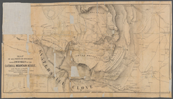
Map of the White Mountains of…
Sketch showing the progress o…
New Haven, Connecticut
Vineyard Sound from Wood's Ho…
Nantucket Sound: western part
m
Colton's map of the county of…
Stedman's new map of the city…
Map of Duchess County, New Yo…
Hypsometric map of the United…
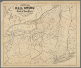
Revised map of the rail roads…
Stanford's library map of Nor…
Map of all points of interest…
m
The languages and races of Da…
Citizens and Travelers' Guide…
m
Citizens & traverlers guide m…