Click to visit the main New York Public Library Homepage
The New York Public Library
Digital Collections
About Digital Collections
Browse
Search only public domain materials
Items
Collections
Divisions
Home
Search
Browse
About
Search only public domain materials
Items
Collections
Divisions
Digital Collections
Using Images
Using Data
Search
Filtered search
Show filters
Hide filters
Show Only Public Domain
topic
x
Administrative and political divisions
Railroads
5
Landowners
2
Piers
2
Real property
2
More
Less
name
Julius Bien & Co
4
Strum, G. P. (Gustave P.)
3
United States. General Land Office
3
Rand McNally and Company
2
American Photo-Lithographic Company
1
More
Less
collection
Maps of North America
11
Maps of New York City and State
5
place
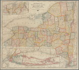
New York (State)
5
Manhattan (New York, N.Y.)
3
New York (N.Y.)
3
Long Island (N.Y.)
2
Boston
1
More
Less
genre
Maps
16
Cadastral maps
2
publisher
Department of the Interior, General Land Office
2
C.E. Hammett, Jr
1
Everts & Kirk, publishers
1
General Land Office
1
J.B. Beers & Co
1
More
Less
division
Map Division
16
type
x
cartographic
Date Range
to
16 results found
Filtering on:
x
Date
: 1885 - 1885
x
Topic
: Administrative and political divisions
x
Type
: cartographic
Sort by:
Title
Date created
Date digitized
Sequence
Map of Minnesota : compiled f…
Indian Territory
Rand, McNally & Co.'s. Colora…
Official topographical map of…
State of Iowa
Map of Chattanooga, Tenn.
State of Illinois
Map of the city of Jacksonvil…
Map of Newport, R.I.
City of Taunton: [Massachuset…
Map of Boston for 1885: publi…
m
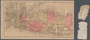
Map of Long Island
Rand McNally & Co.'s new rail…
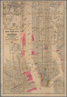
Map of New York City and surr…
Monteith's map of the City of…
m
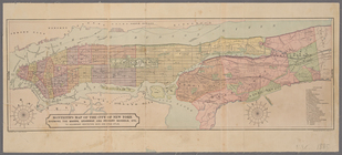
Map of New-York City / prepar…
End of results
|
Top