Click to visit the main New York Public Library Homepage
The New York Public Library
Digital Collections
About Digital Collections
Browse
Search only public domain materials
Items
Collections
Divisions
Home
Search
Browse
About
Search only public domain materials
Items
Collections
Divisions
Digital Collections
Using Images
Using Data
Search
Filtered search
Show filters
Hide filters
Show Only Public Domain
topic
x
Railroads
Administrative and political divisions
5
Counties
3
Postal service
3
Ferries
1
More
Less
name
Nicholson, W. L
2
Rand McNally and Company
2
United States. Post Office Department
2
Berlandi & Bott
1
Conover, Allan D
1
More
Less
collection
Maps of North America
9
Maps of New York City and State
4
place
New York (State)
4
Long Island (N.Y.)
2
New York
2
New York (N.Y.)
2
Bronx (New York, N.Y.)
1
More
Less
genre
Maps
13
publisher
Post Office Department
2
Cram & Stebbins
1
Department of the Interior, General Land Office
1
E. Robinson
1
Fort Worth and Denver Railway
1
More
Less
division
Map Division
13
type
x
cartographic
Date Range
to
13 results found
Filtering on:
x
Date
: 1885 - 1885
x
Topic
: Railroads
x
Type
: cartographic
Sort by:
Title
Date created
Date digitized
Sequence
m
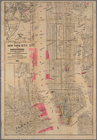
Robinson's map of New York Ci…
Official map of Michigan : ra…
Map showing the line of the N…
Map of Minnesota : compiled f…
Railroad map of Wisconsin
Map of northwest Texas and th…
m
Post route map of the State o…
Post route map of the States …
State of Iowa
Map of the all-water route fr…
m
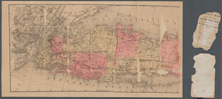
Map of Long Island
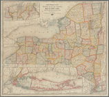
Rand McNally & Co.'s new rail…
Map of New York City and surr…
End of results
|
Top