Click to visit the main New York Public Library Homepage
The New York Public Library
Digital Collections
About Digital Collections
Browse
Search only public domain materials
Items
Collections
Divisions
Home
Search
Browse
About
Search only public domain materials
Items
Collections
Divisions
Digital Collections
Using Images
Using Data
Search
Filtered search
Show filters
Hide filters
Show Only Public Domain
topic
Exhibitions
18
Railroads
5
Transportation
5
Housing development
3
Bridges
2
More
Less
name
New York World's Fair (1939-1940 : New York, N.Y.)
18
Grand Central Terminal (New York, N.Y.)
16
New York (N.Y.). Committee on Slum Clearance
2
Regional Plan Association (New York, N.Y.)
2
Triborough Bridge Authority
2
More
Less
collection
William J. Wilgus papers
21
Bancker plans
20
New York World's Fair 1939 and 1940 Incorporated records
18
Century Company records
9
Robert Moses papers
4
More
Less
place
New York
29
New York (State)
28
New York (N.Y.)
6
United States
4
Brooklyn Bridge (New York, N.Y.)
2
More
Less
genre
Maps
81
Surveys
20
Plans
19
land surveys
18
Correspondence
8
More
Less
publisher
Charles Francis Press
2
Triborough bridge authority
2
Fort Dearborn Pub. Co
1
division
x
Manuscripts and Archives Division
type
x
cartographic
text
18
still image
5
Date Range
to
82 results found
Filtering on:
x
Date
: 1887 - 1975
x
Division
: Manuscripts and Archives Division
x
Type
: cartographic
Sort by:
Title
Date created
Date digitized
Sequence
m
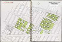
Knickerbocker Village
Site plan, [Page 16 and 17]
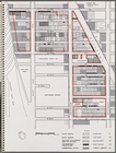
Map illustrating structures n…
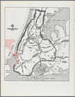
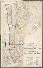
New York City with proposed B…
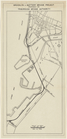
Brooklyn-Battery Bridge Proje…
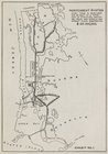
Map of Proposed Belt Railways…
Preliminary Study for a Great…
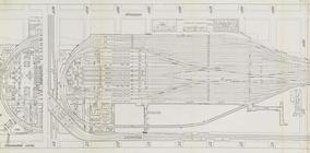
Express level - 1st half
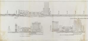
Sections and Elevations - 1st…
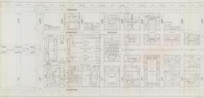
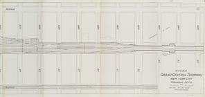
Street Level - 1st half
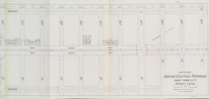
Street Level - 2nd half
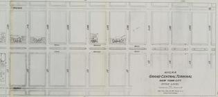
Office level left side
Office level right side
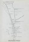
Map. Manhattan's Railroad ent…
Map 10 overhead foot bridges …
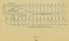
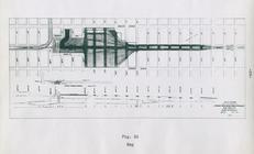
Map depot and yard (figure 5)
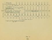
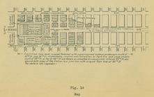
Map station and yard (figure …
Map. Manhattan's Railroad ent…
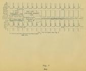
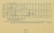
Map (figure 14)
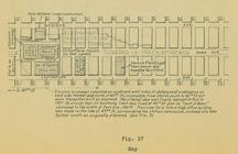
Map (figure 17)
Map (figure 19)
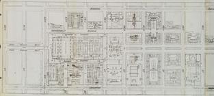
Suburban Level - 1st half.
Suburban Level - 2nd half.
The subway problem: map of in…
Map showing relation of the I…
H4. Map (Scheme B) illustrati…
Plan for preservation of Audu…
Map, Copake (Columbia County,…
m
Reid, Harry Fielding
m
Memoranda
m
4 views and a plan of Dr. All…
m
Law, E.M
m
Pearce, Nicholas Bartlett
m
Park, L.Y
m
Hill, Daniel Harvey
m
Washburn, R.C
m
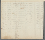
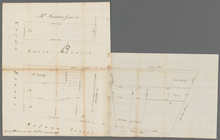
Lots on the north east side o…
m
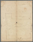
Abbington and Fitzroy Roads
m
Tivoli calculation for Peter …
m
Colonel De Lancey's cleared l…
m
Totten and Crossfield's divis…
m
The late John Quackenboss's e…
m
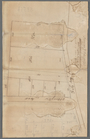
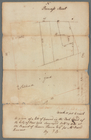
Bowery Lane
m
Stone Street and Broad Street
m
Lot in Princess Street
m
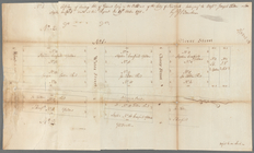
Pearl Street
m
Rear part of lot 1424 Norfolk…
m
B. Peck heirs at Water and Fr…
m
Water and Front Streets, Peck…
m
Greenwich, Washington, Robert…