Click to visit the main New York Public Library Homepage
The New York Public Library
Digital Collections
About Digital Collections
Browse
Search only public domain materials
Items
Collections
Divisions
Home
Search
Browse
About
Search only public domain materials
Items
Collections
Divisions
Digital Collections
Using Images
Using Data
Search
Filtered search
Show filters
Hide filters
Show Only Public Domain
topic
Real property
344
Railroads
34
Local transit
21
Piers
17
Streets
16
More
Less
name
Bromley, George Washington
135
Bromley, Walter Scott
135
G.W. Bromley & Co
135
E. Robinson Co
119
Robinson, E. (Elisha)
119
More
Less
collection
Atlases of New York City
330
Maps of New York City and State
107
place
x
New York
New York (State)
437
Manhattan (New York, N.Y.)
181
New York (N.Y.)
138
Brooklyn (New York, N.Y.)
130
More
Less
genre
x
Maps
Cadastral maps
10
Index maps
7
Manuscript maps
5
Indexes
4
More
Less
publisher
G.W. Bromley & Co
135
E. Robinson Co
119
E.B. Hyde & Co
76
publisher not identified
9
Rand, McNally & Co
5
More
Less
division
Map Division
436
Manuscripts and Archives Division
1
type
cartographic
437
text
6
still image
2
Date Range
to
437 results found
Filtering on:
x
Date
: 1888 - 1898
x
Genre
: Maps
x
Place
: New York
Sort by:
Title
Date created
Date digitized
Sequence
Map of the City of New York a…
Map of the Hackensack & New Y…
Map of the Harlem River and S…
m
New guide map of New York Cit…
m
Manhattan borough and part of…
The Matthews-Northrup up-to-d…
m
Plans for the improvement of …
Plan of Bay Ridge Parkway
Map of the enlarged city of B…
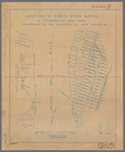
Map of the 23rd and 24th ward…
Proposed site on Staten Islan…
Bridgman's new map of the Cit…
m
Rand McNally & Co.'s road map…
Map of New York City : showin…
Livingston Heights : Livingto…
m
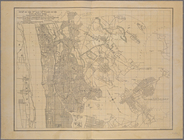
Topographical map of New York…
Map of the borough of Manhatt…
Map of New York City and vici…
m
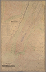
Vicinity of New York
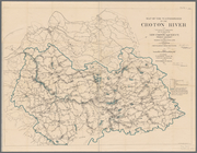
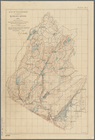
Plate I. Map of the watershed…
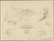
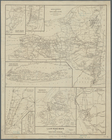
Plate IV. Sketches of village…
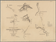
Plate III : Sketches of villa…
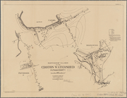
Plate II. Sketches of village…
Map of watershed of Ramapo Ri…
L.A.W. road maps of New York …
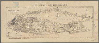
Long Island for the summer
m
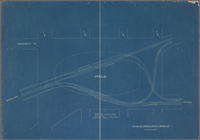
Plan and profile showing the …
m
New map of the borough of Man…
m
General design for a system o…
Map of the 23rd and 24th ward…
m
Map of New York City : showin…
Map of New York City
Map of New York City between …
Manhattan borough and part of…
m
New York City elevated railro…
Map of New York City: prepare…
The heart of greater New York…
m
The Bridgman's new map of the…
Map of part of New York City:…
Map showing the relative posi…
m
Map of the original grants of…
Mulberry Bend District. Map b…
Map of New York City
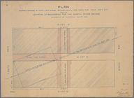
Location of North River Bridg…
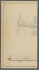
Plan showing changes in West …
Rand, McNally & Co.'s map of …
Plan of the tracks under Unio…
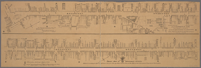
Pocket map of Broadway, New Y…
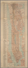
Proposed Harlem River Drive f…
m
Map of New York City : showin…
1
2
Previous
Next
1
2
Previous
Next