Click to visit the main New York Public Library Homepage
The New York Public Library
Digital Collections
About Digital Collections
Browse
Search only public domain materials
Items
Collections
Divisions
Home
Search
Browse
About
Search only public domain materials
Items
Collections
Divisions
Digital Collections
Using Images
Using Data
Search
Filtered search
Show filters
Hide filters
Show Only Public Domain
topic
Real property
375
Maps
225
Local transit
48
Population
44
Railroads
40
More
Less
name
G.W. Bromley & Co
522
Bromley, George Washington
230
Bromley, Walter Scott
230
New York (N.Y.). Board of Estimate and Apportionment
228
Fairchild Aerial Camera Corporation
127
More
Less
collection
Atlases of New York City
1081
Maps of New York City and State
148
Atlases, gazetteers, guidebooks and other books
2
Cartographic materials from the Emmet collection of manuscripts etc. relating to American history
1
Lawrence H. Slaughter Collection of English maps, charts, globes, books and atlases
1
place
x
New York (N.Y.)
New York (State)
502
Bronx (New York, N.Y.)
353
New York
271
Manhattan (New York, N.Y.)
243
More
Less
genre
Maps
1199
Cadastral maps
57
Indexes
17
Manuscript maps
15
Index maps
12
More
Less
publisher
G.W. Bromley & Co
472
Sanborn Map Company
133
M.B. Brown Printing & Binding Co.,
111
New York (N.Y.). Board of Estimate and Apportionment
74
G. W. Bromley & Co
52
More
Less
division
x
Map Division
type
cartographic
1200
text
77
still image
6
Date Range
to
1,233 results found
Filtering on:
x
Date
: 1895 - 1945
x
Division
: Map Division
x
Place
: New York (N.Y.)
Sort by:
Title
Date created
Date digitized
Sequence
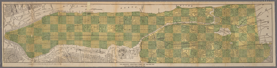
Hammond's complete map of New…
m
Map of Brooklyn
Educational extension work of…
The Evening Mail's complete m…
Rail terminal facilities in G…
Guide map to the Brooklyn and…
Most extraordinary [camera sh…
m
Hammond's complete map of New…
Map of New York City and the …
m
The Rand McNally map of the b…
Panoramic view of New York Ci…
m
The five boroughs of the city…
Map of the country thirty mil…
Map of the New York City metr…
Rand McNally Map of Brooklyn
m
View of the city of New York …
Map of Brooklyn
m
Map of New York City : showin…
m
The Wanamaker diary map of Ne…
m
Tentative height districts, M…
m
Tentative use districts, Manh…
Freight terminal map of New Y…
Center of New York, first cit…
The Merchants' Association's …
m
Manhattan borough and part of…
m
Rand-McNally standard map of …
m
Hagstrom's map of upper New Y…
Williams' map of boroughs of …
Map of boroughs of Manhattan …
m
Authentic street plan of grea…
m
Hammond's new guide map of Ma…
m
Map of New York : showing Leh…
The Matthews-Northrup up-to-d…
Map of the 23rd and 24th ward…
Mapa de la ciudad de Nueva Yo…
Maps accompanying report of M…
The Narrows tunnel : chart of…
m
Map of the underground railwa…
Bridgman's new map of the Cit…
Proposed location of the Narr…
m
Borough of Manhattan, 300 foo…
Freight terminal map of the P…
Block no. 86 : confidential r…
m
Street guide of Manhattan and…
Map of portion of greater New…
m
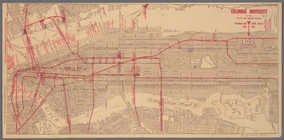
Columbia University in the Ci…
Greater New York's Census dis…
m
Rand McNally commercial map o…
Hagstrom's map of ... New Yor…
m
Map 35 - Richmond
1
2
3
4
5
Previous
Next
1
2
3
4
5
Previous
Next