Click to visit the main New York Public Library Homepage
The New York Public Library
Digital Collections
About Digital Collections
Browse
Search only public domain materials
Items
Collections
Divisions
Home
Search
Browse
About
Search only public domain materials
Items
Collections
Divisions
Digital Collections
Using Images
Using Data
Search
Filtered search
Show filters
Hide filters
Show Only Public Domain
topic
Real property
716
Fire insurance
272
Cities & towns
270
Description and travel
112
Railroads
16
More
Less
name
Sanborn Map Company
272
E. Belcher Hyde Map Company
233
Ullitz, Hugo
233
E.B. Hyde & Co
169
Century Map Company
111
More
Less
collection
Atlases of New York City
757
Atlases of the United States
245
Maps of New York City and State
134
Spezialkarte der Osterreichisch-Ungarischen Monarchie
69
Maps of Asia
38
More
Less
place
New York (State)
740
New York
312
Maps
209
Brooklyn (New York, N.Y.)
190
New York (N.Y.)
164
More
Less
genre
Maps
1288
Atlases
245
Topographic maps
74
Cadastral maps
32
Index maps
5
More
Less
publisher
Sanborn Map Company
400
E. Belcher Hyde
233
Century Map Company
111
K.u.K. Militargeographisches Institut
69
Hyde & Co
64
More
Less
division
Map Division
1228
Milstein Division
29
Manuscripts and Archives Division
22
Schomburg Jean Blackwell Hutson Research and Reference Division
9
General Research Division
4
More
Less
type
x
cartographic
text
20
still image
4
Date Range
to
1,298 results found
Filtering on:
x
Date
: 1900 - 1905
x
Type
: cartographic
Sort by:
Title
Date created
Date digitized
Sequence
m
Report on the work of the com…
Zoological chart of the world…
m
Chart of the world exhibiting…
Records of searches in relati…
Map of the borough of Brookly…
m
Map of property belonging to …
Map of lots belonging to the …
Map of Brooklyn Manor
m
The Blanchard Press correctly…
Rand, McNally & Co.'s new aut…
Map and profile showing sourc…
Brooklyn
Rosedale Square, Rosedale : 4…
m
Rand, McNally & Co.'s complet…
m
New York City and vicinity
Erie Railroad suburban lines
King's bird's-eye view of Bro…
Rand McNally standard map of …
Guide map to the Brooklyn and…
Map of the borough of Brookly…
Map of 272 lots in the 30th w…
The Brooklyn of the future : …
Map showing proposed extensio…
Map of Jamaica Fells : fourth…
Map of the borough of Brookly…
m
King's birds-eye view of Broo…
Rand, McNally & Co.'s new han…
Map of New York City region a…
Rand McNally standard map of …
m
Map of New York City : showin…
Map of the City of New York :…
m
Sea Gate, New York Harbor
Map of Elmhurst Square : situ…
Center of New York, first cit…
m
Rand-McNally standard map of …
m
Map of New York : showing Leh…
m
Map of the borough of Brookly…
m
Map of the underground railwa…
Map of portion of greater New…
m
Town site of La Gloria: looki…
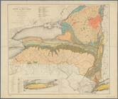
Economic and geologic map of …
Express level - 1st half
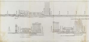
Sections and Elevations - 1st…
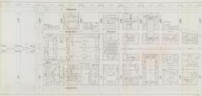
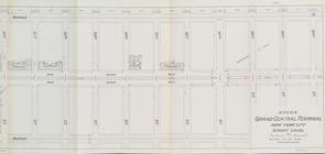
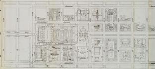
Street Level - 1st half
Street Level - 2nd half
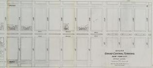
Office level left side
Office level right side
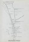
Map. Manhattan's Railroad ent…
Map 10 overhead foot bridges …
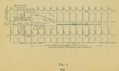
Map depot and yard (figure 5)
1
2
3
4
5
6
Previous
Next
1
2
3
4
5
6
Previous
Next