Click to visit the main New York Public Library Homepage
The New York Public Library
Digital Collections
About Digital Collections
Browse
Search only public domain materials
Items
Collections
Divisions
Home
Search
Browse
About
Search only public domain materials
Items
Collections
Divisions
Digital Collections
Using Images
Using Data
Search
Filtered search
Show filters
Hide filters
Show Only Public Domain
topic
Real property
92
Local transit
31
Railroads
27
Streets
14
Administrative and political divisions
12
More
Less
name
G.W. Bromley & Co
238
Bromley, George Washington
132
Bromley, Walter Scott
132
E. Robinson Co
37
Pidgeon, R. H. (Roger H.)
37
More
Less
collection
Atlases of New York City
403
Maps of New York City and State
100
William J. Wilgus papers
5
I. N. Phelps Stokes Collection of American Historical Prints
2
Atlases, gazetteers, guidebooks and other books
1
place
x
New York (N.Y.)
New York (State)
187
Bronx (New York, N.Y.)
150
New York
148
Manhattan (New York, N.Y.)
120
More
Less
genre
x
Maps
Cadastral maps
53
Manuscript maps
11
Aerial views
6
Index maps
4
More
Less
publisher
G.W. Bromley & Co
186
Sanborn Map Company
128
G. W. Bromley & Co
52
E. Robinson Co
37
Museum of the American Indian, Heye Foundation
12
More
Less
division
Map Division
504
Manuscripts and Archives Division
5
Wallach Division: Print Collection
2
type
cartographic
507
text
6
still image
3
Date Range
to
511 results found
Filtering on:
x
Date
: 1900 - 1918
x
Genre
: Maps
x
Place
: New York (N.Y.)
Sort by:
Title
Date created
Date digitized
Sequence
Hammond's complete map of New…
m
Map of Brooklyn
The Evening Mail's complete m…
Rail terminal facilities in G…
Guide map to the Brooklyn and…
m
Hammond's complete map of New…
Map of New York City and the …
m
The Rand McNally map of the b…
Panoramic view of New York Ci…
m
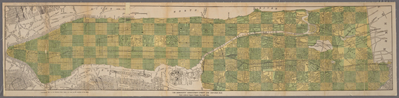
The five boroughs of the city…
Map of the country thirty mil…
Map of the New York City metr…
Rand McNally Map of Brooklyn
m
View of the city of New York …
Map of Brooklyn
m
Map of New York City : showin…
m
Tentative height districts, M…
m
Tentative use districts, Manh…
Freight terminal map of New Y…
Center of New York, first cit…
The Merchants' Association's …
m
Rand-McNally standard map of …
Williams' map of boroughs of …
Map of boroughs of Manhattan …
m
Authentic street plan of grea…
m
Hammond's new guide map of Ma…
m
Map of New York : showing Leh…
Mapa de la ciudad de Nueva Yo…
Maps accompanying report of M…
m
Map of the underground railwa…
m
Borough of Manhattan, 300 foo…
Freight terminal map of the P…
Map of portion of greater New…
m
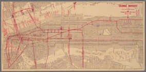
Columbia University in the Ci…
m
Rand McNally commercial map o…
Upper Manhattan, comprising t…
The lower end of Manhattan Is…
The southeastern part of the …
The southwestern part of the …
The northwesterly part of the…
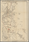
The district of Pelham Neck, …
Southeastern part of the boro…
Werpoes, a village of the Man…
Yorkville and East Harlem in …
Southern part of the borough …
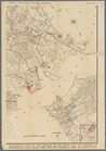
The Long Island City and Newt…
Greater New York and contigou…
Map of Proposed Belt Railways…
Preliminary Study for a Great…
The subway problem: map of in…
1
2
3
Previous
Next
1
2
3
Previous
Next