Click to visit the main New York Public Library Homepage
The New York Public Library
Digital Collections
About Digital Collections
Browse
Search only public domain materials
Items
Collections
Divisions
Home
Search
Browse
About
Search only public domain materials
Items
Collections
Divisions
Digital Collections
Using Images
Using Data
Search
Filtered search
Show filters
Hide filters
Show Only Public Domain
topic
Real property
1097
Fire insurance
583
Cities & towns
498
Zoning
118
Railroads
10
More
Less
name
Sanborn Map Company
583
G.W. Bromley & Co
284
Ullitz, Hugo
243
E. Belcher Hyde (Firm)
129
New York (N.Y.). Board of Estimate and Apportionment
119
More
Less
collection
Atlases of New York City
1224
Atlases of the United States
113
Maps of New York City and State
54
Atlases, gazetteers, guidebooks and other books
1
place
x
New York (State)
New York
779
Manhattan (New York, N.Y.)
303
Maps
257
Queens (Borough)
129
More
Less
genre
Maps
1366
Atlases
112
Indexes
17
Pamphlets
9
Index maps
7
More
Less
publisher
Sanborn Map Company
498
E. Belcher Hyde
243
G.W. Bromley & Co
236
E. Belcher-Hyde
112
Sanborn Map Co
85
More
Less
division
x
Map Division
type
cartographic
1380
text
37
still image
1
Date Range
to
1,392 results found
Filtering on:
x
Date
: 1913 - 1919
x
Division
: Map Division
x
Place
: New York (State)
Sort by:
Title
Date created
Date digitized
Sequence
Hammond's complete map of New…
Map of Flatbush Meadows : sit…
m
Metropolitan district local a…
The Evening Mail's complete m…
Tracts and farms with street …
New York and vicinity roads a…
m
Official map covering territo…
Opening Hell Gate at a cost o…
Rail terminal facilities in G…
Railroads in Manhattan, Jerse…
Carl Schurz Park
Park between 35th and 36th St…
Birdseye view of greater New …
Hagstrom's map of lower New Y…
m
Riverside Park
m
Map of Manhattan showing the …
Block sketch 1679, New York C…
m
Hammond's complete map of New…
Map of New York City and the …
m
Map of the borough of Brookly…
m
The Rand McNally map of the b…
Brooklyn Liberty Loan Committ…
Bush Terminal, map showing bu…
m
The five boroughs of the city…
Map of the country thirty mil…
Map of the New York City metr…
Colonial Park
Rand McNally Map of Brooklyn
City Hall Park
Map of Brooklyn
m
New quick reference street in…
m
Hammond's complete map of Bro…
Greater New York and its harb…
Plan of the great meadows of …
m
Tentative height districts, M…
m
Tentative use districts, Manh…
Commission on building distri…
Block line map of the heavy v…
Maps accompanying report of M…
m
Borough of Manhattan, 300 foo…
Freight terminal map of the P…
m
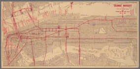
Columbia University in the Ci…
m
Rand McNally commercial map o…
Map of Morningside Park
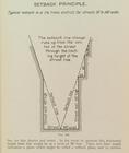
Setback principle
m
Map of New York City
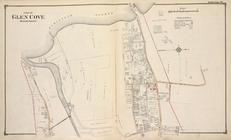
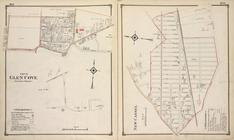
Part of Glen Cove (Harbor Por…
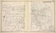
Hicksville
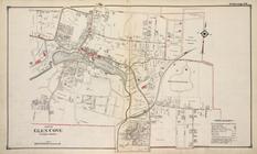
Part of Glen Cove (Easternly …
Part of Glen Cove (Easternly …
1
2
3
4
5
6
Previous
Next
1
2
3
4
5
6
Previous
Next