Click to visit the main New York Public Library Homepage
The New York Public Library
Digital Collections
About Digital Collections
Browse
Search only public domain materials
Items
Collections
Divisions
Home
Search
Browse
About
Search only public domain materials
Items
Collections
Divisions
Digital Collections
Using Images
Using Data
Search
Filtered search
Show filters
Hide filters
Show Only Public Domain
topic
Historic buildings
1
Historic sites
1
Land grants
1
Manors
1
New York (State)
1
More
Less
name
Annand, George
1
Brooklyn Daily Eagle (Firm)
1
Geological Survey (U.S.)
1
Hagstrom Map Company
1
Mayer, Max
1
More
Less
collection
x
Maps of New York City and State
place
New York (State)
2
Historical geography
1
Hudson River Valley (N.Y. and N.J.)
1
Hudson River Valley (N.Y. and N.J.) -- History -- Maps
1
Hudson River Valley (N.Y. and N.J.) -- Maps, Pictorial
1
More
Less
genre
x
Maps
Pictorial maps
1
publisher
Brooklyn Daily Eagle
1
Max Mayer
1
Rand McNally & C
1
S.M. Stanley Co
1
The Survey
1
division
Map Division
5
type
cartographic
5
Date Range
to
5 results found
Filtering on:
x
Date
: 1931 - 1937
x
Genre
: Maps
x
Collection
: Maps of New York City and State
For more collection details, visit the
Maps of New York City and State collection page
.
Sort by:
Title
Date created
Date digitized
Sequence
m
Hagstom's map of Long Island …
Staten Island, N.Y., ed. of F…
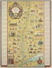
Romance map of the Hudson Riv…
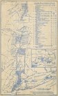
Patroonships, manors and seig…
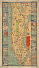
Manhattan, first city in Amer…